 Lebensraumvernetzung Geodata
Geonetwork Version: LRVA-2022: Sonderkarten zur Lebensraumvernetzung für den Waldentwicklungsplan (WEP)
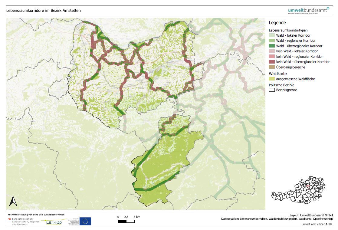
LRVA-2022: Generated standard map representation of the special topic maps for ecological corridors in Austria for the forest development plan. The maps are automatically updated as soon as the data basis (=modification of ecological corridors or modification forest mask from the Federal Forest Research Centre /BFW) changes. Details see also end report available: https://docs.umweltbundesamt.at/s/AzZrHid6q9wkDDM.
QGIS-Modell for the maps generation available here: https://docs.umweltbundesamt.at/s/CjTNNLzPEKbNWyX
Simple
Information de l'identification
- Date (Dernière mise à jour)
- 2022-07-01
- Edition
- Version 2022-10-16
- But
- Basis for protecting ecological corridors in spatial planning and by nature conservation. Basis for the consideration of ecological corridors in nature conservation planning.
- Etat
- Mis à jour continue
Point de contact
- Type de représentation spatiale
- Raster
- Catégorie ISO
-
- Environnement
Etendue
))
Etendue
Etendue temporelle
- Période
- 2022-07-01
- Fréquence de mise à jour
- Continue
- Mots clés (Localisation)
-
- LRVA-2022
- WEP
- Mots clés
-
- Austria
Contraintes sur la ressource
- Contraintes d'accès
- Autres restrictions
- Contraintes d'utilisation
- Autres restrictions
- Autres contraintes
- Creative Commons Lizenz CC-BY-AT 4.0
- Langue
- Deutsch
- Encodage de caractères
- Utf8
- Informations supplémentaires
- See Endreport: https://geonode.lebensraumvernetzung.at/documents/111
Informations sur la distribution
- Ressource en ligne
-
LRVA_WEP_BGL.zip
All special maps on habitat connectivity at Burgenland
- Ressource en ligne
-
LRVA_WEP_KNT.zip
All special maps on habitat connectivity at Carinthia
- Ressource en ligne
-
Karte der Ressource
All special maps on habitat connectivity at Carinthia
- Ressource en ligne
-
LRVA_WEP_OOE.pdf
All special maps for habitat connectivity in Upper Austria
- Ressource en ligne
-
LRVA_WEP_SALZBURG.pdf
All special maps for habitat connectivity in Salzburg
- Ressource en ligne
-
LRVA_WEP_STK.pdf
All special maps for habitat connectivity at Styria
- Ressource en ligne
-
LRVA_WEP_TIROL.pdf
All special maps for habitat connectivity in Tyrol
- Ressource en ligne
-
LRVA_WEP_VBG.pdf
All special maps for habitat connectivity in Vorarlberg
- Ressource en ligne
-
LRVA_WEP_WIEN.pdf
All special maps for habitat connectivity in Vienna
Généalogie des ressources
- Généralités sur la provenance
- The data set is created automatically using the WEP tools which was developed within the project "Ecological corridores for insects!. The data basis is the integral data set on ecological corridors, which is automatically processed cartographically. The second dataset ist the forest mask of Austria which is provided by the Federal Forest Research Centre (BFW)
- Niveau
- Collection de données
Information sur le système de référence
- Nom du système de référence
- EPSG: 31287
Métadonnées
- Identifiant de la fiche
- urn:uuid/e569664c-0f81-4943-83e0-6404cd98299f
- Langue
- English
- Encodage de caractères
- Utf8
- Langue
- Français
- Langue
- Deutsch
- Langue
- Chineseutres
- Langue
- Spanish; Castilian
- Langue
- Arabic
- Langue
- Russian
Point de contact
- Lien vers la métadonnée
- https://geonetwork.lebensraumvernetzung.at/geonetwork/srv/api/records/e569664c-0f81-4943-83e0-6404cd98299f
- Informations de date (Révision)
- 2025-09-25T19:00:53
- Informations de date (Création)
- 2022-07-01T14:46:24
Norme des métadonnées
- Titre
- ISO 19115-3
Étendue spatiale
