 Lebensraumvernetzung Geodata
Type of resources
Available actions
Topics
Keywords
Contact for the resource
Provided by
Years
Representation types
Update frequencies
status
Scale
-
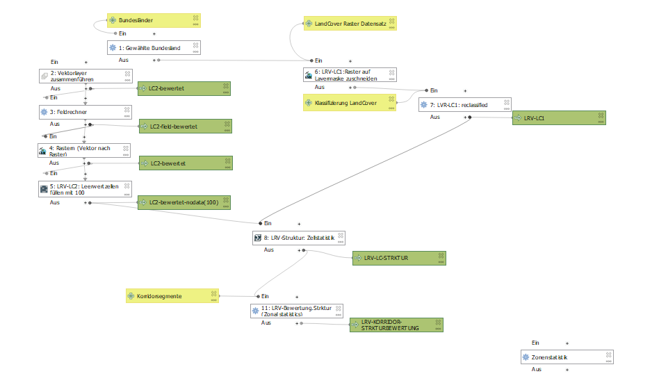
QGIS Modelle für die Berechnung der Bewertung der Lebensraumkorridore in Österreich. in einem Modell ist der Algorithmus für die Segmentierung des Liniengraphen der Lebensraumkorridore in Österreich verfügbar. Im anderen Modell sind die Algorithmen für die Bewertung der Lebensraumkorridorsegmente hinsichtlich der Ausstattung mit Landschaftselementen, der Durchlässigkeit der Landschafsstruktur und der Gesamtindex der Durchlässigkeit der sich aus den beiden erstgenannten zusammensetzt.
-
Expert designation of habitat corridors at local, regional and supraregional level. Client for the Pinzgau: Salzburg Provincial Government Department of Spatial Planning and Department of Nature Conservation, Salzburg Hunting Association, Pinzgau Regional Planning. Client for the Lungau, Pongau, Tennengau and Flachgau: Department of Spatial Planning and Department of Nature Conservation, Salzburg Hunting Association. Regional and supra-regional green corridors were included in the regional programs of the Pinzgau and decreed.
-
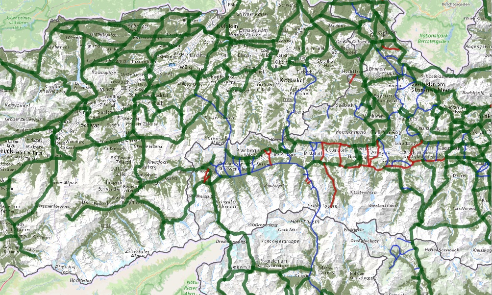
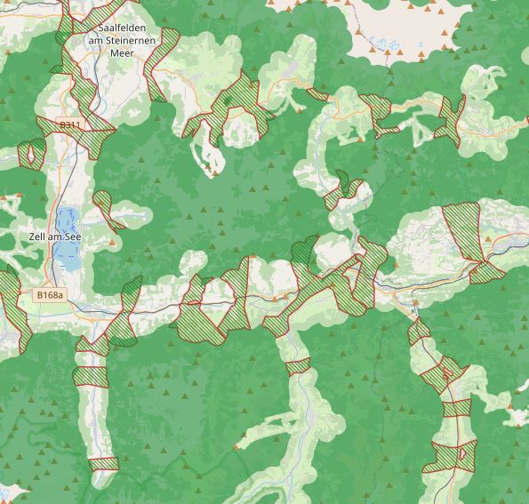
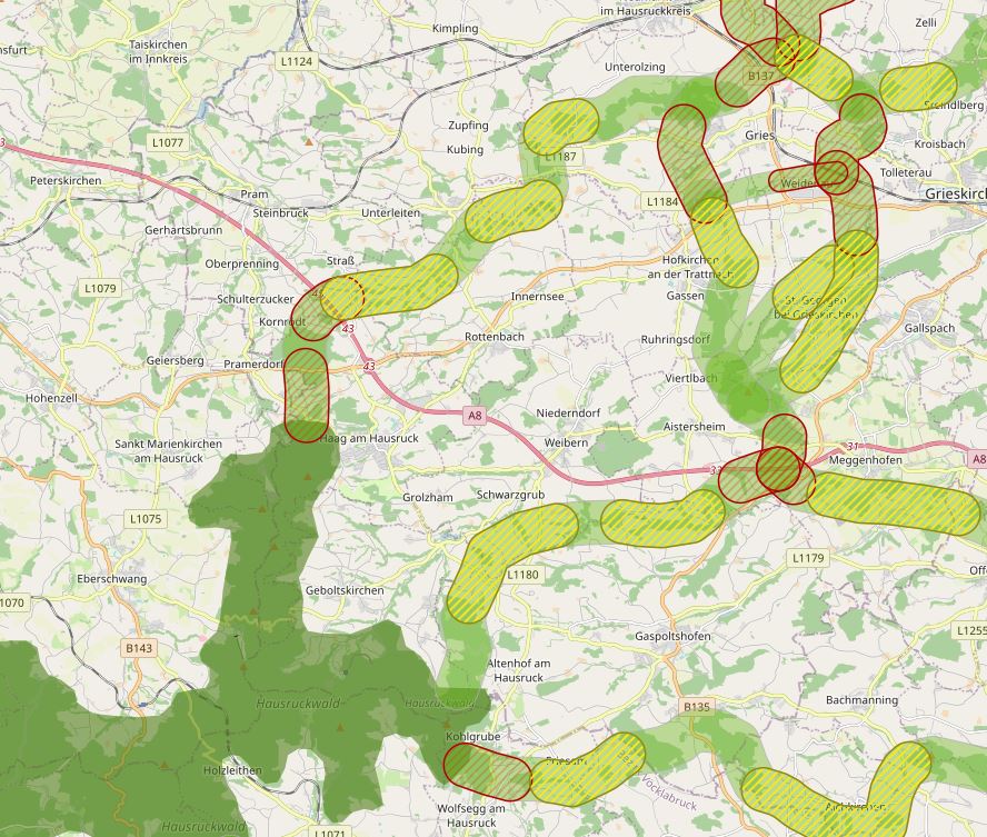
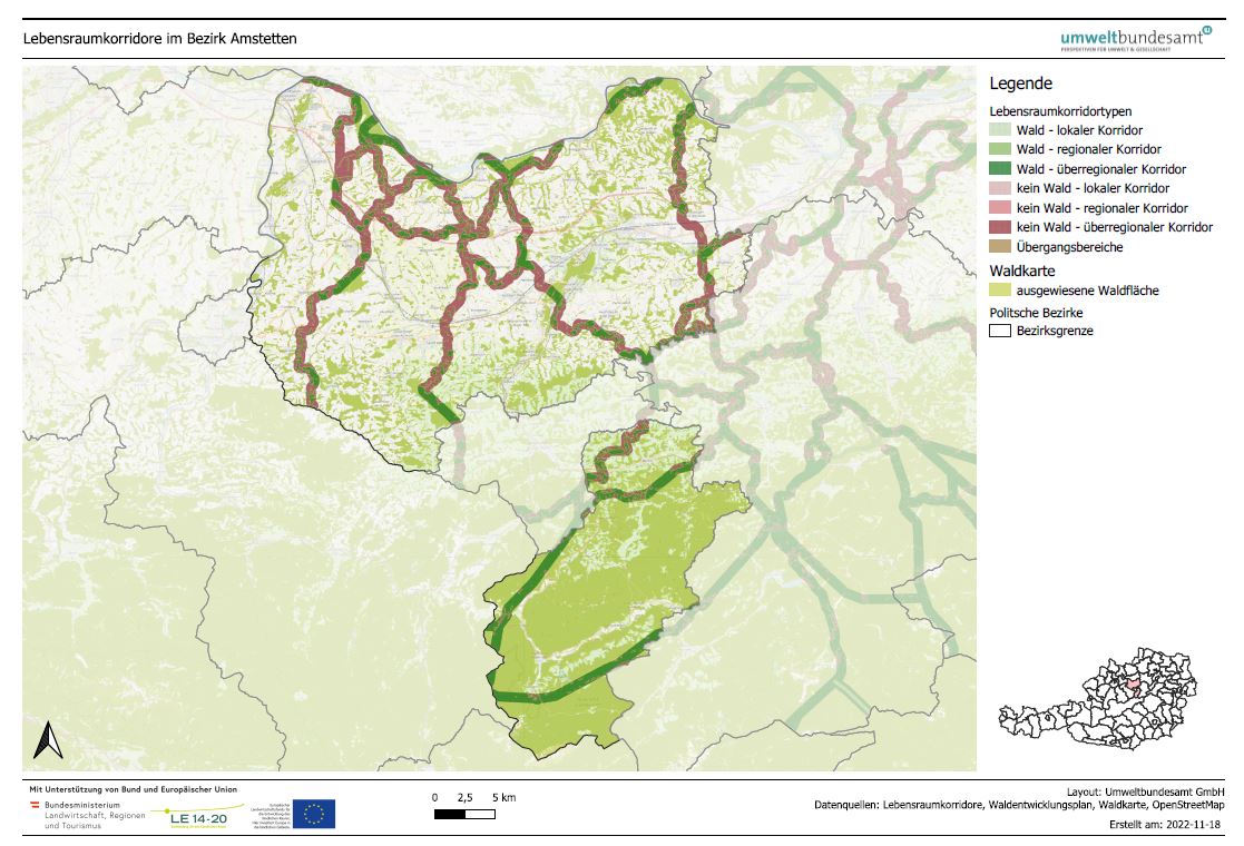
LRVA-2025: Current version of the integral dataset on habitat connectivity in Austria. This dataset takes into account all datasets and designations of habitat corridors from scientific projects and public sector projects (federal provinces). The dataset has been evaluated by the experts of the Cooridnation Platform "Habitat Connectivity Austria" and is updated as soon as new information and designations from projects are available. Further details are available in the endreport: https://docs.umweltbundesamt.at/s/AzZrHid6q9wkDDM As part of the update, the underlying data model was adapted. It is now possible to track all changes made during the update. All updated and valid habitat corridors can be obtained by selecting all edges that have the value “true” in the “valid” data set property. All edges with the value “false” are no longer valid. The reasons for the changes are noted in the ‘comment’ data record property. Most of the changes are so-called “technical changes.” As part of these changes, corridors have been adapted accordingly due to errors in the spatial location of existing crossing structures. The reclassification of corridors is due to new planned or adapted locations of wildlife crossing aids along the existing route. Description of the feature properties see feature catalog: https://geonetwork.lebensraumvernetzung.at/geonetwork/srv/ger/catalog.search#/metadata/e8044763-deb8-43d9-9d51-72b891fe5813 Data set download at: https://docs.umweltbundesamt.at/s/ep9JF44TjYxDY54, also includes QGIS project for direct use of the GPKG file. Two visualizations available. - Corridors classified by corridor category (supra-regional | regional | local) (see Quicklook) - Change layer: Current corridors and all outdated/revised corridor sections
-
LRVA-2022: Current version of the integral dataset on habitat connectivity in Austria. This dataset takes into account all datasets and designations of habitat corridors from scientific projects and public sector projects (federal provinces). The dataset has been evaluated by the experts of the Cooridnation Platform "Habitat Connectivity Austria" and is updated as soon as new information and designations from projects are available. Further details are available in the endreport: https://docs.umweltbundesamt.at/s/AzZrHid6q9wkDDM
-
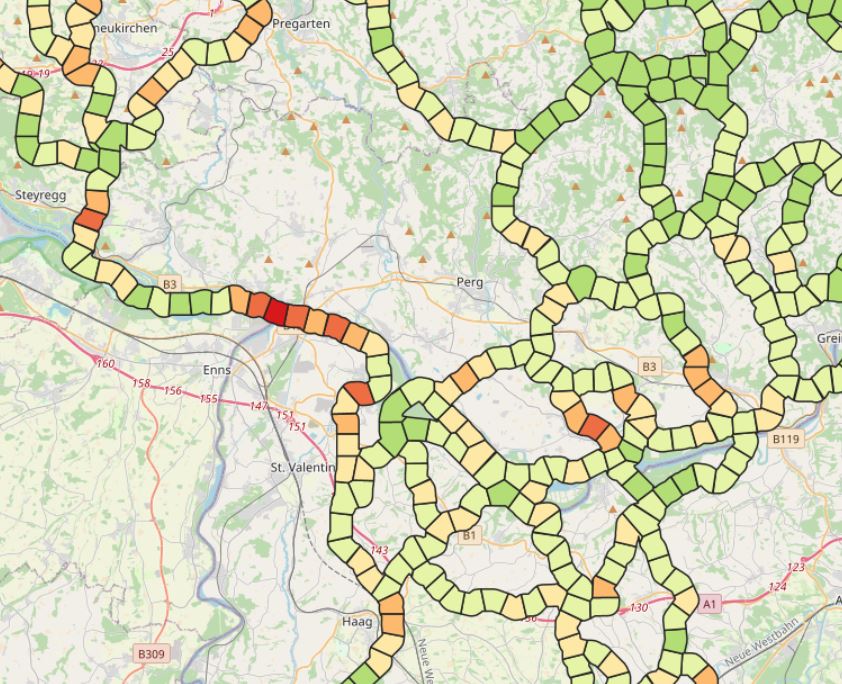
LRVA-2022: Evaluation of ecological corridor axes with regard to the permeability of sections of the ecological corridor. On the one hand, the landscape structure is assessed with regard to its permeability (LC structure index) and on the other hand, the landscape elements equipment of the ecological corridor segment (LE equipment index) is considered. The combination of these two indicators results in the combined ecological corridore index, which gives a good overview of ecological corridor areas with low permeability.
-
The project contributes significantly to a successful and long-term implementa-tion and safeguarding of habitat connectivity in Austria. In addition to the net-working function of habitat corridors, the aspect of how habitat corridors can also be used or adapted for the protection and improvement of insect diversity in Austria was addressed for the first time. Work package 1 is dedicated to the analysis of habitat features and landscape structures with regard to their qualitative (diversity) and quantitative (abun-dance) suitability for insects. The extrapolation of the results of work package 1 implemented in work pack-age 2 provides a first area-wide overview of the structural connectivity of habi-tat corridors in Austria and their suitability for the dispersal and protection of insect diversity. Work package 3 is dedicated to the development of a guideline for assessing the permeability of existing habitat corridors. With the definition of the most important indicators for the assessment of planned measures within the corri-dors, a standardised set of rules for nature conservation assessments is availa-ble for the first time, on which the leading experts in the field of habitat connec-tivity have agreed. Awareness-raising measures are an essential prerequisite for achieving the broadest possible acceptance of habitat connectivity among regional actors (e.g. farmers and landowners). This is the focus of work package 4. For a sustainable protection of the habitat corridors, it is essential to make the habitat corridors visible in an official national document. This issue is addressed in work package 5 by the implementation of a process that allows a widely auto-mated production of specific maps on the topic of habitat connectivity embed-ded in the Austrian forest development plan. A further milestone is the establishment of the “Coordination Platform for Habi-tat Connectivity in Austria” in work package 6, which consists of the most im-portant experts in the field of habitat connectivity in Austria. The objectives of the coordination platform are the regular exchange of experience, a unified and coherent representation of the actors in habitat connectivity and the promotion of the protection of habitat corridors in Austria.
-
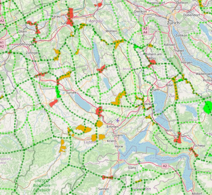
In Switzerland, there are 304 wildlife corridors of supra-regional importance (as of 2020). They connect fragmented ecosystems or suitable habitats and are vital for wildlife. This is because roads and railways form insurmountable barriers for many wild animals. Both large wild animals such as deer and stags, medium-sized ones such as foxes and hares, and small ones such as amphibians or bats need to be able to move for food and reproduction. An assessment of wildlife corridors came to the following conclusion: 47 corridors (16%) are largely disrupted and can no longer be used by wildlife; over half (171 corridors, 56%) are significantly to severely impaired; less than a third (86 corridors, 28 %) can be classified as intact. Geodata information: In a first step, the known wildlife corridors were recorded canton by canton from existing data and potential corridors were identified using GIS and divided into wildlife corridors of supraregional, regional and local interest. Subsequently, the main features of the supraregional and regional network system were visualised for the whole of Switzerland. The corridors were then classified as wildlife corridors of supraregional or regional interest according to the importance of the axis on which they lie. The data for the connecting axes and wildlife corridors were recorded and processed in GIS by the Swiss Ornithological Institute Sempach. The supraregional corridors and the connecting axes were updated by the FOEN in 2012 on the basis of information provided by the cantonal hunting administrations.
-
LRVA-2022: Guideline for assessing the permeability of corridors. This guide provides assistance for the assessment of potential disturbance sources and conflicts of objectives within ecological corridors and should subsequently lead to a standardisation of expert assessments in the field of nature conservation. The guide contains the most important definitions, such as the minimum widths of ecological corridors or which objects represent an absolute barrier within a corridor. The guidelines were agreed upon and approved by renowned experts in the field of ecological corridors who have joined together in the Coordination Platform for Ecological Corridors in Austria.
-
The specific designation of supra-regional migration corridors for larger, preferably forest-bound wildlife is intended to ensure, improve and, if necessary, restore the functionality of a statewide biotope and habitat network. For further information see: http://www.ooe-umweltanwaltschaft.at/xbcr/SID-B49D7CBE-852A8EF6/wildtierkorridore_ooe_2012.pdf
-
LRVA-2022: Generated standard map representation of the special topic maps for ecological corridors in Austria for the forest development plan. The maps are automatically updated as soon as the data basis (=modification of ecological corridors or modification forest mask from the Federal Forest Research Centre /BFW) changes. Details see also end report available: https://docs.umweltbundesamt.at/s/AzZrHid6q9wkDDM. QGIS-Modell for the maps generation available here: https://docs.umweltbundesamt.at/s/CjTNNLzPEKbNWyX