 Lebensraumvernetzung Geodata
LRVA-2022: Bewertung der Lebensraumkorridore Österreich (Version 2022-10-16)
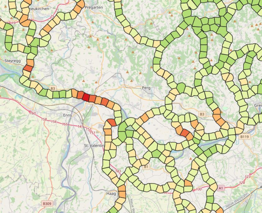
LRVA-2022: Evaluation of ecological corridor axes with regard to the permeability of sections of the ecological corridor. On the one hand, the landscape structure is assessed with regard to its permeability (LC structure index) and on the other hand, the landscape elements equipment of the ecological corridor segment (LE equipment index) is considered. The combination of these two indicators results in the combined ecological corridore index, which gives a good overview of ecological corridor areas with low permeability.
Simple
Identification info
- Date (Last Update)
- 2022-07-01
- Edition
- Version 2022-10-16
- Purpose
- Basis for protecting ecological corridors in spatial planning and by nature conservation. Basis for the consideration of ecological corridors in nature conservation planning.
- Status
- On going
Point of contact
- Spatial representation type
- Vector
Spatial resolution
Equivalent scale
- Denominator
- 25000
- Topic category
-
- Environment
Extent
))
Extent
Temporal extent
- Time period
- 2022-07-01
- Maintenance and update frequency
- Continual
- Keywords (topic)
-
- Austria2022
- LRVA-2022
- Keywords (Place)
-
- Austria
Resource constraints
- Access constraints
- Other restrictions
- Use constraints
- Other restrictions
- Other constraints
- Creative Commons Lizenz CC-BY-AT 4.0
- Language
- Deutsch
- Character encoding
- UTF8
- Supplemental Information
- See Report: https://geonode.lebensraumvernetzung.at/documents/107/download
Distribution Information
- OnLine resource
-
Map of the resource
Map of evaluation of permability of the Austrian ecological network
- OnLine resource
-
Download dataset (Geopackage-format)
Evaluation of ecological corridor axes with regard to the permeability of sections of the ecological corridor. Dataset and QGIS-Project
- OnLine resource
-
geonode:LRVA_Vernetzungsindizes1
LRVA-Index-Ausstattung mit Landschaftselemente 2022
- OnLine resource
-
geonode:LRVA_Vernetzungsindizes0
LRVA-Index Landschaftsstruktur 2022
- OnLine resource
-
geonode:LRVA_Vernetzungsindizes
LRVA-Vernetzungsindizes 2022
- OnLine resource
-
geonode:LRVA_Vernetzungsindizes1
LRVA-Index-Ausstattung mit Landschaftselemente 2022
- OnLine resource
-
geonode:LRVA_Vernetzungsindizes0
LRVA-Index Landschaftsstruktur 2022
- OnLine resource
-
geonode:LRVA_Vernetzungsindizes
LRVA_Vernetzungsindizes 2022
Resource lineage
- Statement
- Data set takes into account all existing data sets from scientific projects and projects of the public sector (federal states). All datasets considered are referenced in the linked resources and are also available in this portal.
Reference System Information
- Reference system identifier
- EPSG: 31287
Metadata
- Metadata identifier
- urn:uuid/380747db-7e67-41cd-a1c8-055e05b5743c
- Language
- English
- Character encoding
- UTF8
- Language
- Français
- Language
- Deutsch
- Language
- Chineseutres
- Language
- Spanish; Castilian
- Language
- Arabic
- Language
- Russian
Point of contact
- Metadata linkage
- https://geonetwork.lebensraumvernetzung.at/geonetwork/srv/api/records/380747db-7e67-41cd-a1c8-055e05b5743c
- Date info (Revision)
- 2026-01-27T20:41:16
- Date info (Creation)
- 2022-07-01T14:46:24
Metadata standard
- Title
- ISO 19115-3
Overviews
Spatial extent
Provided by
