 Lebensraumvernetzung Geodata

Type of resources
Available actions
Topics
Keywords
Contact for the resource
Provided by
Years
Formats
Representation types
Update frequencies
status
Service types
Scale
Resolution
-
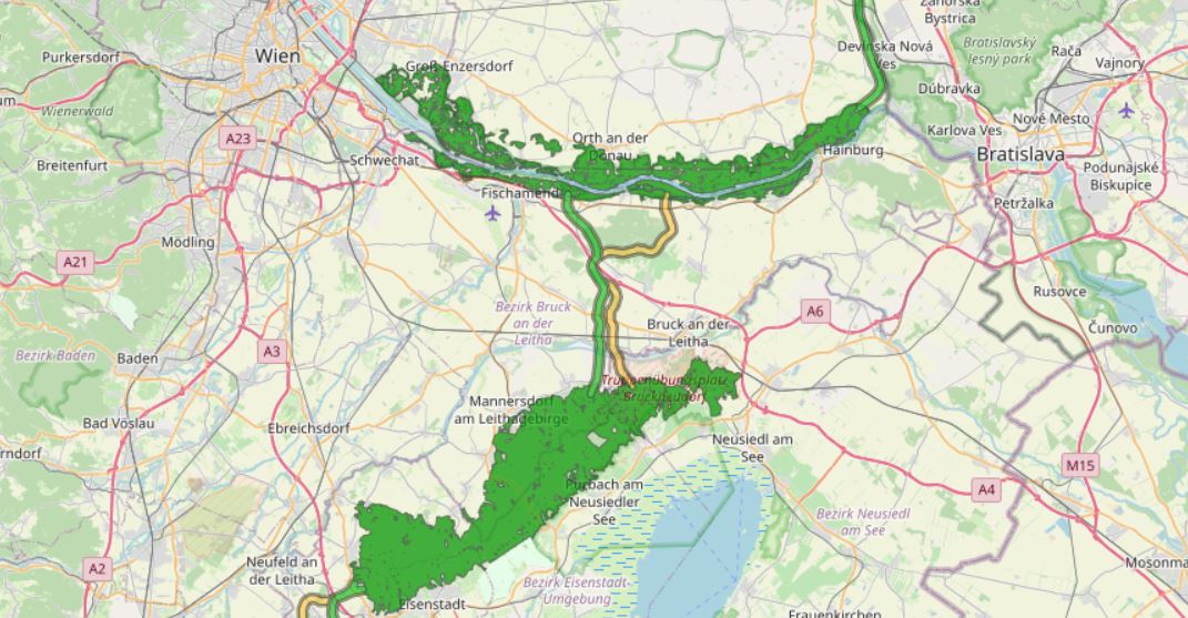
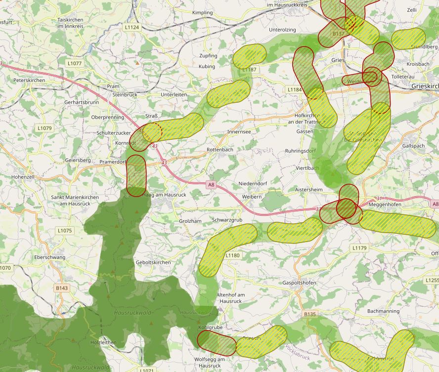
Modeling the course of the Alpen Kaparten corridor. Consists of the four Bottlenecks and additional core zones of wildlife in-betweeen them. Attributes: -101 - primarily core zone, buffered from centerline 250m to each side -102 - primarily border zone, buffered from core zone 150m -201 - secondary core zone, buffered from centerline 250m to each side -202 - secondary border zone, buffered from core zone 150m -112 - primarily, core - and borderzone are together, buffered 400m from the centerline on each side -0 - core zones of wildlife, big forested areas, only rough delineation
-
This dataset is the definitive set of locality boundaries for the state of Victoria as defined by Local Government and registered by the Registrar of Geographic Names. The boundaries are aligned to Vicmap Property. This dataset is part of the Vicmap Admin dataset series.
-
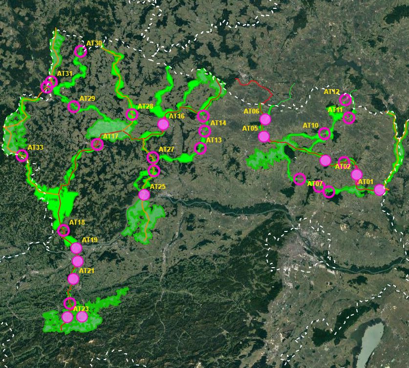
First of all, a GIS model was created, which aims to use a least-cost path algorithm to determine the general course of the corridors as precisely and in as much detail as possible. This is particularly necessary because the area under investigation, at more than 30,000km², covers more than a third of the total size of Austria - and thus could not be processed in a justifiable time frame on an expert basis alone. In a next step, the results of the GIS model will be used as a basis for further expert work. This offers the possibility to additionally take into account local particularities as well as findings from workshops, etc. This way, a result can be elaborated that can be used as a basis for the development of the GIS model. In this way, a result can be developed that is spatially accurate even at a scale of 1 : 10,000 - and not only in the bottlenecks. - ConNat-AT as Shapefile:ConNat-AT-KorrEngstKern-UTM-N33.zip Zip -File: complete dataset of all narrows, corridors and core areas in Austria (Esri Shapefile, EPSG 25833 (UTM N33, ETRS 1989)). Attributes: Name (designation), Cat (category: 1 core area, 2 corridor, 3 narrows), Info (link to further information), ESPrior (narrows priority: 0 no narrows, 1 primary narrows, 2 secondary narrows), Area (in ha). - ConNat-AT and Lower Austrian axes as shapefile:NOeWildKorrMittellinieEPSG25833.zip Zip file: Corridor axes in Lower Austria: ConNat and already existing axes from Lower Austria Atlas (Esri Shapefile, EPSG 25833 (UTM N33, ETRS 1989)). Attributes: Name (designation), SymbolID (0 international corridor, 1 supraregional corridor, 2 regional corridor), Buffer (radius in metres), LASTUPDATE (last change).
-
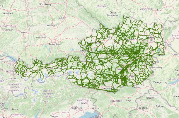
Austrian Ecological Corridors - final version. Valued by the experts of the federal provinces. Prepared in the framework of the LE project "Habitat connectivity to safeguard biodiversity in Austria".
-
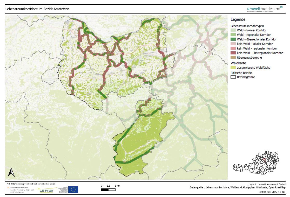
LRVA-2022: Generated standard map representation of the special topic maps for ecological corridors in Austria for the forest development plan. The maps are automatically updated as soon as the data basis (=modification of ecological corridors or modification forest mask from the Federal Forest Research Centre /BFW) changes. Details see also end report available: https://docs.umweltbundesamt.at/s/AzZrHid6q9wkDDM
-
This catalog is for registering all metadata records held by the Geofffrey's Tube Palace Hotel Ballroom.
-
The specific designation of supra-regional migration corridors for larger, preferably forest-bound wildlife is intended to ensure, improve and, if necessary, restore the functionality of a statewide biotope and habitat network. For further information see: http://www.ooe-umweltanwaltschaft.at/xbcr/SID-B49D7CBE-852A8EF6/wildtierkorridore_ooe_2012.pdf
-
In spring 2019, the NP Thayatal GmbH commissioned the Büro für Wildökologie und Forstwirtschaft e.U. (Office for Wildlife Ecology and Forestry) to prepare a wildcat corridor plan in the Wald- & Weinviertel in Austria and the districts of South Bohemia and South Moravia in the Czech Republic as part of the Interreg project MaGICLandscapes. For the study area in Austria and the Czech Republic, the habitat potential of the European wildcat is to be estimated in the form of a habitat model. Based on the habitat model, a corridor analysis will show the possible distribution routes of the cat. As a further step, a strategy and action plan will be developed to provide a basis for improving and expanding migration corridors and thus dispersal opportunities for the wildcat along the green infrastructure. Within the framework of the MaGICLandscapes project, the research results serve as a basis for the planning, construction and management of green infrastructure. For the National Park Thayatal, they serve as input for the further procedure in wildcat management and are taken into account in the wildcat population support concept. See further information: https://lebensraumvernetzung.at/publikationen/Leitner-2020-Wildkatzenkorridorplan-Endbericht-2021-04-19-web.pdf
-
During National Science Week on Sunday 26th August 2007, Geoscience Australia opened its doors to the community to showcase a diverse range of work activities. Members of the public had the opportunity to discover how earthquakes are detected, pan for gold, tour the building, view Australia in 3D, become a seafloor detective and talk to the people who work for Australia's national geoscience research organisation. The photographs of that open day have been converted into thumbmail images and are available on the GA web site.
-
The project contributes significantly to a successful and long-term implementa-tion and safeguarding of habitat connectivity in Austria. In addition to the net-working function of habitat corridors, the aspect of how habitat corridors can also be used or adapted for the protection and improvement of insect diversity in Austria was addressed for the first time. Work package 1 is dedicated to the analysis of habitat features and landscape structures with regard to their qualitative (diversity) and quantitative (abun-dance) suitability for insects. The extrapolation of the results of work package 1 implemented in work pack-age 2 provides a first area-wide overview of the structural connectivity of habi-tat corridors in Austria and their suitability for the dispersal and protection of insect diversity. Work package 3 is dedicated to the development of a guideline for assessing the permeability of existing habitat corridors. With the definition of the most important indicators for the assessment of planned measures within the corri-dors, a standardised set of rules for nature conservation assessments is availa-ble for the first time, on which the leading experts in the field of habitat connec-tivity have agreed. Awareness-raising measures are an essential prerequisite for achieving the broadest possible acceptance of habitat connectivity among regional actors (e.g. farmers and landowners). This is the focus of work package 4. For a sustainable protection of the habitat corridors, it is essential to make the habitat corridors visible in an official national document. This issue is addressed in work package 5 by the implementation of a process that allows a widely auto-mated production of specific maps on the topic of habitat connectivity embed-ded in the Austrian forest development plan. A further milestone is the establishment of the “Coordination Platform for Habi-tat Connectivity in Austria” in work package 6, which consists of the most im-portant experts in the field of habitat connectivity in Austria. The objectives of the coordination platform are the regular exchange of experience, a unified and coherent representation of the actors in habitat connectivity and the promotion of the protection of habitat corridors in Austria.