 Lebensraumvernetzung Geodata
Ecological Corridors Upper Austria
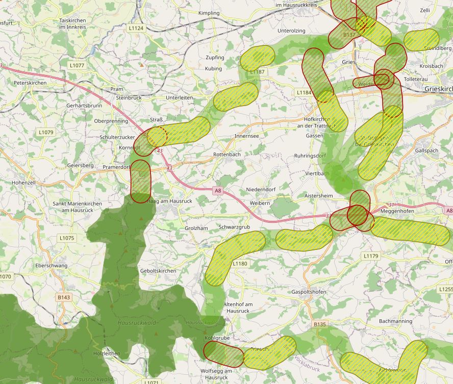
The specific designation of supra-regional migration corridors for larger, preferably forest-bound wildlife is intended to ensure, improve and, if necessary, restore the functionality of a statewide biotope and habitat network. For further information see: http://www.ooe-umweltanwaltschaft.at/xbcr/SID-B49D7CBE-852A8EF6/wildtierkorridore_ooe_2012.pdf
Simple
Identification info
- Date (Creation)
- 2012-05-01
- Edition
- Version 1
- Purpose
- Visualization and safeguarding of habitat corridors in Upper Austria
- Status
- Accepted
Originator
- Spatial representation type
- Vector
Spatial resolution
Equivalent scale
- Denominator
- 25000
- Topic category
-
- Biota
Extent
N
S
E
W
))
Extent
Temporal extent
- Time period
- 2012-05-01
- Maintenance and update frequency
- Irregular
- Keywords (Theme)
-
- Upper Austria
- Keywords (Place)
-
- World
Resource constraints
- Access constraints
- Copyright
- Use constraints
- Copyright
- Other constraints
- Release cleared for any use. No parcel sharp demarcation. Intersections with the cadastre are prohibited.
- Language
- English
- Character encoding
- UTF8
- Supplemental Information
- No parcel sharp demarcation. Intersections with the cadastre are prohibited.
Distribution Information
- OnLine resource
-
Data layers Ecological Corridors Upper Austria (ESRI-Shapefile)
Alle Datenschichten zur Lebensraumvernetzung in OÖ (ESRI-Shapefile)
Resource lineage
- Statement
- wtk-ooe_corridors. Polygons of all corridor sections in for habitat connectivity. Category A corridors (international) are 1000 m wide, Category B corridors (regional) are 500 m wide. The name of the corridors is found in the <name> field and is composed of that of a two-digit code and the category (e.g. GR_19A). wtk-ooe_yellowzones Polygons of all yellow zones (= corridor subsections with restricted functionality) in Upper Austria. The name of each yellow zone can be found in the <name> field, the assigned corridor section in the <corridor> field. At junctions of corridor sections, yellow zones can spatially overlap (with each other or also with red zones). wtk-ooe_redzones Polygons of all red zones (= corridor subsections with severely limited functionality) in Upper Austria. The name of each redzone is found in the <name> field, the assigned corridor section in the <corridor> field. At junctions of corridor sections, red zones can spatially overlap (among each other or also with yellow zones) wtk-ooe_habitats Polygons of current and potential habitat for forest-dwelling large mammals. Habitat quality is differentiated by zone. Transition zones (ÜZ in the <category> box) have medium habitat propensity, while core zones (KZ in the <category> box) have high habitat propensity. As so-called stepping stones (TS in the field <category>), the forests along the Danube were identified separately. In terms of habitat connectivity, these are equivalent to the core zones (or corridors) in terms of their importance. wtk-ooe_connection Line of the central corridor axis and its (partly hypothetical) course within the designated habitats to establish a nationwide closed habitat connectivity.
- Hierarchy level
- Dataset
Reference System Information
- Reference system identifier
- EPSG:31255
Metadata
- Metadata identifier
- urn:uuid/cbdf846f-32e1-4a7d-a71f-3db6e4e3e0b6
- Language
- English
- Character encoding
- UTF8
- Language
- Français
- Language
- Deutsch
- Language
- Chineseutres
- Language
- Spanish; Castilian
- Language
- Arabic
- Language
- Russian
Point of contact
- ()
- Metadata linkage
- https://geonetwork.lebensraumvernetzung.at/geonetwork/srv/api/records/cbdf846f-32e1-4a7d-a71f-3db6e4e3e0b6
- Date info (Creation)
- 2022-08-23T10:00:03
- Date info (Revision)
- 2022-08-23T10:16:50
Metadata standard
- Title
- ISO 19115-3
Overviews
o%C3%B6.JPG
Spatial extent
N
S
E
W
Provided by

Associated resources
Not available