 Lebensraumvernetzung Geodata
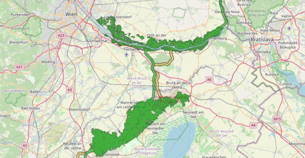
Alpine Carpathian Corridor (ACC Corridor)
Modeling the course of the Alpen Kaparten corridor. Consists of the four Bottlenecks and additional core zones of wildlife in-betweeen them.
Attributes:
-101 - primarily core zone, buffered from centerline 250m to each side
-102 - primarily border zone, buffered from core zone 150m
-201 - secondary core zone, buffered from centerline 250m to each side
-202 - secondary border zone, buffered from core zone 150m
-112 - primarily, core - and borderzone are together, buffered 400m from the centerline on each side
-0 - core zones of wildlife, big forested areas, only rough delineation
Simple
Identification info
- Date (Creation)
- 2018-01-01
- Edition
- Version 1
- Purpose
- Modeling of the course of the Alpen Kaparten Corridor. For a detailed description of the designation methodology and further information and data sets on the Alpen Kaparten Corridor see: http://geo.ivfl.boku.ac.at/. The action plan developed within the project and further information on the project can be found at: http://www.alpenkarpatenkorridor.at/.
- Status
- Accepted
Originator
- Spatial representation type
- Vector
Spatial resolution
Equivalent scale
- Denominator
- 50000
- Topic category
-
- Biota
Extent
N
S
E
W
))
Extent
Temporal extent
- Time period
- 2018-01-01
- Maintenance and update frequency
- As needed
- Keywords (Theme)
-
- Alpine Carpathian Corridor
- Keywords
-
- World
Resource constraints
- Access constraints
- Copyright
- Use constraints
- Copyright
- Language
- English
- Character encoding
- UTF8
- Supplemental Information
- Data set is not suitable for parcel delineation / analysis!
Distribution Information
- OnLine resource
- Alpine Carpathian Corridor (ESRI Shapefile)
Resource lineage
- Statement
- For detailed information on the designation methodology and further details on data quality, see: http://geo.ivfl.boku.ac.at/
- Hierarchy level
- Dataset
Reference System Information
- Reference system identifier
- EPSG: 32633
Metadata
- Metadata identifier
- urn:uuid/a8add026-8ffe-4fc0-8d87-fb5866f20af4
- Language
- English
- Character encoding
- UTF8
- Language
- Français
- Language
- Deutsch
- Language
- Chineseutres
- Language
- Spanish; Castilian
- Language
- Arabic
- Language
- Russian
Point of contact
- Metadata linkage
- https://geonetwork.lebensraumvernetzung.at/geonetwork/srv/api/records/a8add026-8ffe-4fc0-8d87-fb5866f20af4
- Date info (Revision)
- 2022-08-23T19:00:39
- Date info (Creation)
- 2009-07-02T14:46:24
Metadata standard
- Title
- ISO 19115-3
Overviews
acc.JPG
Spatial extent
N
S
E
W
Provided by

Associated resources
Not available