 Lebensraumvernetzung Geodata
ConNat . Connecting Nature
ConNat . Connecting Nature
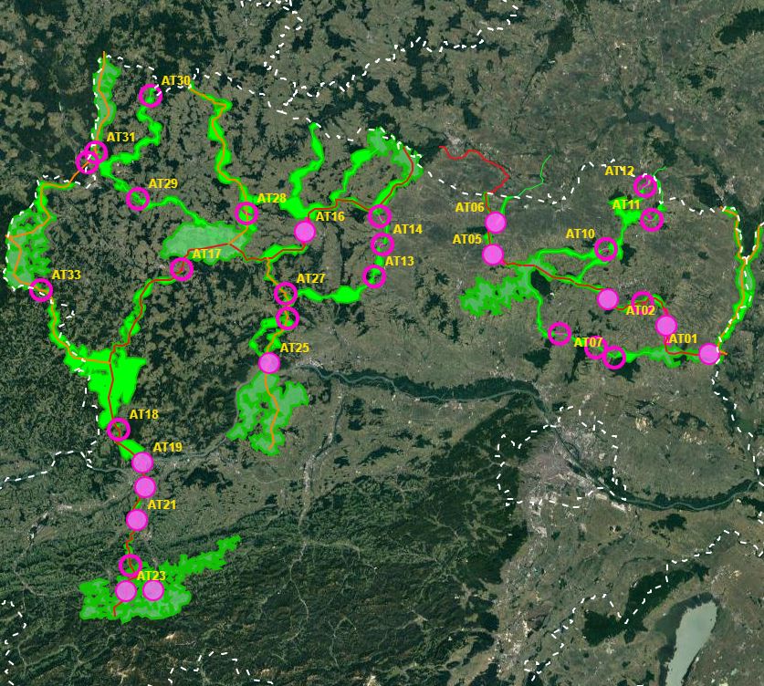
First of all, a GIS model was created, which aims to use a least-cost path algorithm to determine the general course of the corridors as precisely and in as much detail as possible. This is particularly necessary because the area under investigation, at more than 30,000km², covers more than a third of the total size of Austria - and thus could not be processed in a justifiable time frame on an expert basis alone.
In a next step, the results of the GIS model will be used as a basis for further expert work. This offers the possibility to additionally take into account local particularities as well as findings from workshops, etc. This way, a result can be elaborated that can be used as a basis for the development of the GIS model.
In this way, a result can be developed that is spatially accurate even at a scale of 1 : 10,000 - and not only in the bottlenecks.
- ConNat-AT as Shapefile:ConNat-AT-KorrEngstKern-UTM-N33.zip
Zip -File: complete dataset of all narrows, corridors and core areas in Austria (Esri Shapefile, EPSG 25833 (UTM N33, ETRS 1989)). Attributes: Name (designation), Cat (category: 1 core area, 2 corridor, 3 narrows), Info (link to further information), ESPrior (narrows priority: 0 no narrows, 1 primary narrows, 2 secondary narrows), Area (in ha).
- ConNat-AT and Lower Austrian axes as shapefile:NOeWildKorrMittellinieEPSG25833.zip
Zip file: Corridor axes in Lower Austria: ConNat and already existing axes from Lower Austria Atlas (Esri Shapefile, EPSG 25833 (UTM N33, ETRS 1989)). Attributes: Name (designation), SymbolID (0 international corridor, 1 supraregional corridor, 2 regional corridor), Buffer (radius in metres), LASTUPDATE (last change).
Zuerst wurde ein GIS Modell erstellt, das den Anspruch hat, mit einem Least Cost Path Algorithmus die generellen Verläufe der Korridore so genau und detailliert als möglich zu erabeiten. Das ist vor allem deshalb notwendig, weil das Untersuchungsgebiet mit mehr als 30 000km² mehr als ein Drittel der Gesamtgröße Österreichs umfasst - und somit nicht nur expertenbasiert in einem vertretbaren Zeitrahmen bearbeitbar wäre.
In einem nächsten Schritt wird dann, auf den Ergebnissen vom GIS Modell aufbauend, expertenbasiert weitergearbeitet. Das bietet die Möglichkeit, zusätzlich lokale Besonderheiten als auch Erkenntnisse aus Workshops, etc. mitzuberücksichtigen.
Damit kann ein Ergebnis erarbeitet werden, das in der räumlichen Genauigkeit auch noch im Maßstab 1 : 10 000 Gültigkeit hat – und das nicht nur in den Engstellen.
- ConNat-AT als Shapefile:ConNat-AT-KorrEngstKern-UTM-N33.zip
Zip -File: gesamter Datensatz aller Engstellen, Korridore und Kerngebiete in Österreich (Esri Shapefile, EPSG 25833 (UTM N33, ETRS 1989)) Attribute: Namen (Bezeichnung), Kat (Kategorie: 1 Kerngebiet, 2 Korridor, 3 Engstelle), Info (Link zu weiteren Informationen), ESPrior (Engstellenpriorität: 0 keine Engstelle, 1 primäre Engstelle, 2 sekundäre Engstelle), Flaeche (in ha)
- ConNat-AT und NÖ Achsen als Shapefile:NOeWildKorrMittellinieEPSG25833.zip
Zip -File: Korridorachsen in Niederösterreich: ConNat und bereits vorhandene Achsen von NÖ Atlas (Esri Shapefile, EPSG 25833 (UTM N33, ETRS 1989)) Attribute: Name (Bezeichnung), SymbolID (0 internationaler Korridor, 1 überregionaler Korridor, 2 regionaler Korridor), Puffer (Radius in Meter), LASTUPDATE (letzte Änderung)
Simple
Information de l'identification
Identification info
Identification info
Identification info
Identification info
Identification info
Identification info
-
Date (Création)Date (Creation)Date (Creation)Date (Creation)Date (Creation)Date (Creation)Date (Creation)
- 2021-08-24
-
ButPurposePurposePurposePurposePurposePurpose
-
Safeguarding habitat corridors in Lower AustriaAbsicherung der Lebensraumkorridore in Niederösterreich.
-
EtatStatusStatusStatusStatusStatusStatus
A l’origine de
Originator
Originator
Originator
Originator
Originator
Originator
-
Type de représentation spatialeSpatial representation typeSpatial representation typeSpatial representation typeSpatial representation typeSpatial representation typeSpatial representation type
-
VecteurVectorVectorVectorVectorVectorVector
Résolution spatiale
Spatial resolution
Spatial resolution
Spatial resolution
Spatial resolution
Spatial resolution
Spatial resolution
Echelle comparative
Equivalent scale
Equivalent scale
Equivalent scale
Equivalent scale
Equivalent scale
Equivalent scale
-
DénominateurDenominatorDenominatorDenominatorDenominatorDenominatorDenominator
- 10000
-
Catégorie ISOTopic categoryTopic categoryTopic categoryTopic categoryTopic categoryTopic category
-
-
Biologie, faune et floreBiotaBiotaBiotaBiotaBiotaBiota
-
Etendue
Extent
Extent
Extent
Extent
Extent
Extent
))
Etendue
Extent
Extent
Extent
Extent
Extent
Extent
Etendue temporelle
Temporal extent
Temporal extent
Temporal extent
Temporal extent
Temporal extent
Temporal extent
-
PériodeTime periodTime periodTime periodTime periodTime periodTime period
- 2021-01-24
-
Fréquence de mise à jourMaintenance and update frequencyMaintenance and update frequencyMaintenance and update frequencyMaintenance and update frequencyMaintenance and update frequencyMaintenance and update frequency
-
Lorsque nécessaireAs neededAs neededAs neededAs neededAs neededAs needed
- Keywords (ThèmeThemeThemeThemeThemeThemeTheme)
-
-
ConNatConNat
-
- Keywords (LocalisationPlacePlacePlacePlacePlacePlace)
-
-
World
-
Contraintes sur la ressource
Resource constraints
Resource constraints
Resource constraints
Resource constraints
Resource constraints
Resource constraints
-
Contraintes d'accèsAccess constraintsAccess constraintsAccess constraintsAccess constraintsAccess constraintsAccess constraints
-
Droit d’auteur / Droit moral (copyright)CopyrightCopyrightCopyrightCopyrightCopyrightCopyright
-
Contraintes d'utilisationUse constraintsUse constraintsUse constraintsUse constraintsUse constraintsUse constraints
-
Droit d’auteur / Droit moral (copyright)CopyrightCopyrightCopyrightCopyrightCopyrightCopyright
-
Autres contraintesOther constraintsOther constraintsOther constraintsOther constraintsOther constraintsOther constraints
-
not definednicht definiert
-
LangueLanguageLanguageLanguageLanguageLanguageLanguage
- English
-
Encodage de caractèresCharacter encodingCharacter encodingCharacter encodingCharacter encodingCharacter encodingCharacter encoding
-
Utf8UTF8UTF8UTF8UTF8UTF8UTF8
Informations sur la distribution
Distribution Information
Distribution Information
Distribution Information
Distribution Information
Distribution Information
Distribution Information
-
Ressource en ligneOnLine resourceOnLine resourceOnLine resourceOnLine resourceOnLine resourceOnLine resource
-
ConNat-AT-KorrEngstKern-UTM-N33.zipLade von Webseite herunterConNat-AT-KorrEngstKern-UTM-N33.zip (ESRI Shapefile)Lade von Webseite herunterLade von Webseite herunterLade von Webseite herunterLade von Webseite herunter
-Zip -File: complete dataset of all narrows, corridors and core areas in Austria (Esri Shapefile, EPSG 25833 (UTM N33, ETRS 1989)). Attributes: Name (designation), Cat (category: 1 core area, 2 corridor, 3 narrows), Info (link to further information), ESPrior (narrows priority: 0 no narrows, 1 primary narrows, 2 secondary narrows), Area (in ha).Zip -File: gesamter Datensatz aller Engstellen, Korridore und Kerngebiete in Österreich (Esri Shapefile, EPSG 25833 (UTM N33, ETRS 1989)) Attribute: Namen (Bezeichnung), Kat (Kategorie: 1 Kerngebiet, 2 Korridor, 3 Engstelle), Info (Link zu weiteren Informationen), ESPrior (Engstellenpriorität: 0 keine Engstelle, 1 primäre Engstelle, 2 sekundäre Engstelle), Flaeche (in ha)
-
Ressource en ligneOnLine resourceOnLine resourceOnLine resourceOnLine resourceOnLine resourceOnLine resource
-
NOeWildKorrMittellinieEPSG25833.zip (ESRI Shapefile)Lade von Webseite herunterNOeWildKorrMittellinieEPSG25833.zip (ESRI Shapefile)Lade von Webseite herunterLade von Webseite herunterLade von Webseite herunterLade von Webseite herunter
Zip -File: Corridor axes in Lower Austria: ConNat and already existing axes from NÖ Atlas (Esri Shapefile, EPSG 25833 (UTM N33, ETRS 1989)). Attributes: Name (designation), SymbolID (0 international corridor, 1 supraregional corridor, 2 regional corridor), Buffer (radius in metres), LASTUPDATE (last change).Zip -File: Korridorachsen in Niederösterreich: ConNat und bereits vorhandene Achsen von NÖ Atlas (Esri Shapefile, EPSG 25833 (UTM N33, ETRS 1989)) Attribute: Name (Bezeichnung), SymbolID (0 internationaler Korridor, 1 überregionaler Korridor, 2 regionaler Korridor), Puffer (Radius in Meter), LASTUPDATE (letzte Änderung)
-
Ressource en ligneOnLine resourceOnLine resourceOnLine resourceOnLine resourceOnLine resourceOnLine resource
-
Action PlanLade von Webseite herunterAktonsplanLade von Webseite herunterLade von Webseite herunterLade von Webseite herunterLade von Webseite herunter
PDF-Document Action PlanPDF-Document Action Plan
-
Ressource en ligneOnLine resourceOnLine resourceOnLine resourceOnLine resourceOnLine resourceOnLine resource
-
PDF-MapLade von Webseite herunterPDF-KarteLade von Webseite herunterLade von Webseite herunterLade von Webseite herunterLade von Webseite herunter
PDF-Map of corrdiors in Lower AustriaPDF-Karte der Korridore in Niederösterreich
Généalogie des ressources
Resource lineage
Resource lineage
Resource lineage
Resource lineage
Resource lineage
Resource lineage
-
Généralités sur la provenanceStatementStatementStatementStatementStatementStatement
-
See Abstract.: Further detailed information: https://boku.ac.at/rali/geomatics/themenfelder/fernerkundung-und-gis/connat-1Siehe Zusammenfassung Weiterführende Informationen auch unter: https://boku.ac.at/rali/geomatics/themenfelder/fernerkundung-und-gis/connat-1
-
NiveauHierarchy levelHierarchy levelHierarchy levelHierarchy levelHierarchy levelHierarchy level
-
Jeu de donnéesDatasetDatasetDatasetDatasetDatasetDataset
Information sur le système de référence
Reference System Information
Reference System Information
Reference System Information
Reference System Information
Reference System Information
Reference System Information
-
Nom du système de référenceReference system identifierReference system identifierReference system identifierReference system identifierReference system identifierReference system identifier
- EPSG 25833
Metadata
-
Identifiant de la ficheMetadata identifierMetadata identifierMetadata identifierMetadata identifierMetadata identifierMetadata identifier
- urn:uuid/041d6433-072a-40f0-8087-31e728ba8340
-
LangueLanguageLanguageLanguageLanguageLanguageLanguage
- English
-
Encodage de caractèresCharacter encodingCharacter encodingCharacter encodingCharacter encodingCharacter encodingCharacter encoding
-
Utf8UTF8UTF8UTF8UTF8UTF8UTF8
-
LangueLanguageLanguageLanguageLanguageLanguageLanguage
- Français
-
LangueLanguageLanguageLanguageLanguageLanguageLanguage
- Deutsch
-
LangueLanguageLanguageLanguageLanguageLanguageLanguage
- Chineseutres
-
LangueLanguageLanguageLanguageLanguageLanguageLanguage
- Spanish; Castilian
-
LangueLanguageLanguageLanguageLanguageLanguageLanguage
- Arabic
-
LangueLanguageLanguageLanguageLanguageLanguageLanguage
- Russian
Point de contact
Point of contact
Point of contact
Point of contact
Point of contact
Point of contact
Point of contact
-
Lien vers la métadonnéeMetadata linkageMetadata linkageMetadata linkageMetadata linkageMetadata linkageMetadata linkage
- https://geonetwork.lebensraumvernetzung.at/geonetwork/srv/api/records/041d6433-072a-40f0-8087-31e728ba8340
-
Informations de date (Création)Date info (Creation)Date info (Creation)Date info (Creation)Date info (Creation)Date info (Creation)Date info (Creation)
- 2022-08-24T11:34:30
-
Informations de date (Révision)Date info (Revision)Date info (Revision)Date info (Revision)Date info (Revision)Date info (Revision)Date info (Revision)
- 2026-01-27T08:44:08
Norme des métadonnées
Metadata standard
Metadata standard
Metadata standard
Metadata standard
Metadata standard
Metadata standard
-
TitreTitleTitleTitleTitleTitleTitle
-
ISO 19115-3ISO 19115-3
Overviews
Spatial extent
Provided by
