 Lebensraumvernetzung Geodata
ConNat . Connecting Nature
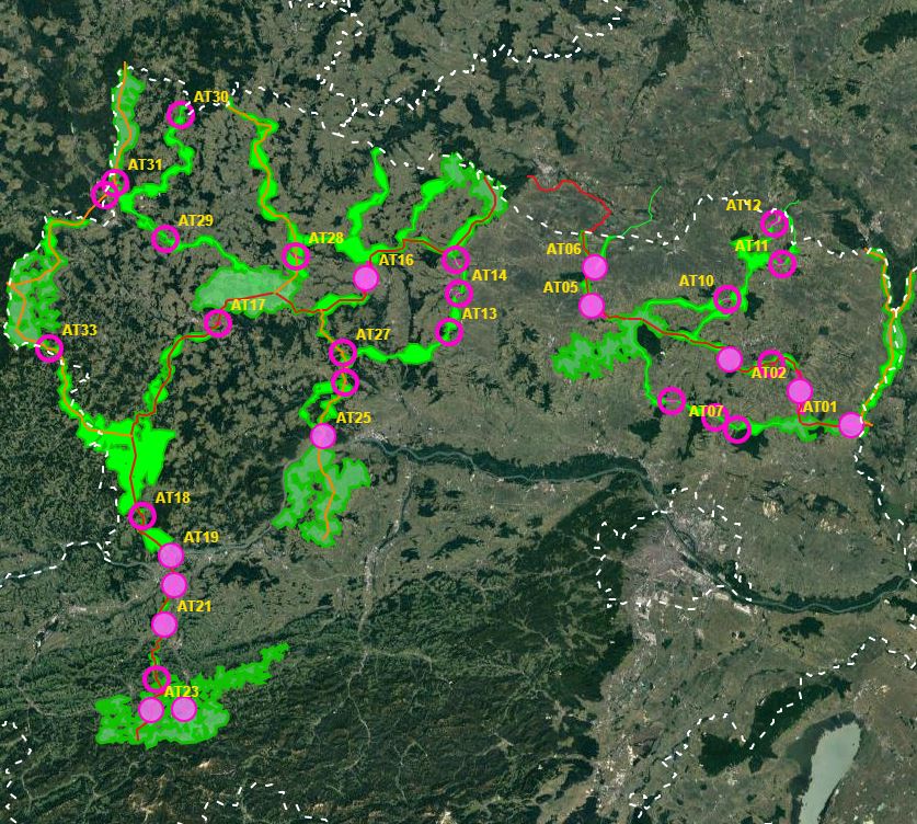
First of all, a GIS model was created, which aims to use a least-cost path algorithm to determine the general course of the corridors as precisely and in as much detail as possible. This is particularly necessary because the area under investigation, at more than 30,000km², covers more than a third of the total size of Austria - and thus could not be processed in a justifiable time frame on an expert basis alone.
In a next step, the results of the GIS model will be used as a basis for further expert work. This offers the possibility to additionally take into account local particularities as well as findings from workshops, etc. This way, a result can be elaborated that can be used as a basis for the development of the GIS model.
In this way, a result can be developed that is spatially accurate even at a scale of 1 : 10,000 - and not only in the bottlenecks.
- ConNat-AT as Shapefile:ConNat-AT-KorrEngstKern-UTM-N33.zip
Zip -File: complete dataset of all narrows, corridors and core areas in Austria (Esri Shapefile, EPSG 25833 (UTM N33, ETRS 1989)). Attributes: Name (designation), Cat (category: 1 core area, 2 corridor, 3 narrows), Info (link to further information), ESPrior (narrows priority: 0 no narrows, 1 primary narrows, 2 secondary narrows), Area (in ha).
- ConNat-AT and Lower Austrian axes as shapefile:NOeWildKorrMittellinieEPSG25833.zip
Zip file: Corridor axes in Lower Austria: ConNat and already existing axes from Lower Austria Atlas (Esri Shapefile, EPSG 25833 (UTM N33, ETRS 1989)). Attributes: Name (designation), SymbolID (0 international corridor, 1 supraregional corridor, 2 regional corridor), Buffer (radius in metres), LASTUPDATE (last change).
Simple
Information de l'identification
- Date (Création)
- 2021-08-24
- But
- Safeguarding habitat corridors in Lower Austria
- Etat
A l’origine de
- Type de représentation spatiale
- Vecteur
Résolution spatiale
Echelle comparative
- Dénominateur
- 10000
- Catégorie ISO
-
- Biologie, faune et flore
Etendue
))
Etendue
Etendue temporelle
- Période
- 2021-01-24
- Fréquence de mise à jour
- Lorsque nécessaire
- Mots clés (Thème)
-
- ConNat
- Mots clés (Localisation)
-
- World
Contraintes sur la ressource
- Contraintes d'accès
- Droit d’auteur / Droit moral (copyright)
- Contraintes d'utilisation
- Droit d’auteur / Droit moral (copyright)
- Autres contraintes
- not defined
- Langue
- English
- Encodage de caractères
- Utf8
Informations sur la distribution
- Ressource en ligne
-
ConNat-AT-KorrEngstKern-UTM-N33.zip
-Zip -File: complete dataset of all narrows, corridors and core areas in Austria (Esri Shapefile, EPSG 25833 (UTM N33, ETRS 1989)). Attributes: Name (designation), Cat (category: 1 core area, 2 corridor, 3 narrows), Info (link to further information), ESPrior (narrows priority: 0 no narrows, 1 primary narrows, 2 secondary narrows), Area (in ha).
- Ressource en ligne
-
NOeWildKorrMittellinieEPSG25833.zip (ESRI Shapefile)
Zip -File: Corridor axes in Lower Austria: ConNat and already existing axes from NÖ Atlas (Esri Shapefile, EPSG 25833 (UTM N33, ETRS 1989)). Attributes: Name (designation), SymbolID (0 international corridor, 1 supraregional corridor, 2 regional corridor), Buffer (radius in metres), LASTUPDATE (last change).
- Ressource en ligne
-
Action Plan
PDF-Document Action Plan
- Ressource en ligne
-
PDF-Map
PDF-Map of corrdiors in Lower Austria
Généalogie des ressources
- Généralités sur la provenance
- See Abstract.: Further detailed information: https://boku.ac.at/rali/geomatics/themenfelder/fernerkundung-und-gis/connat-1
- Niveau
- Jeu de données
Information sur le système de référence
- Nom du système de référence
- EPSG 25833
Métadonnées
- Identifiant de la fiche
- urn:uuid/041d6433-072a-40f0-8087-31e728ba8340
- Langue
- English
- Encodage de caractères
- Utf8
- Langue
- Français
- Langue
- Deutsch
- Langue
- Chineseutres
- Langue
- Spanish; Castilian
- Langue
- Arabic
- Langue
- Russian
Point de contact
- Lien vers la métadonnée
- https://geonetwork.lebensraumvernetzung.at/geonetwork/srv/api/records/041d6433-072a-40f0-8087-31e728ba8340
- Informations de date (Création)
- 2022-08-24T11:34:30
- Informations de date (Révision)
- 2026-01-27T08:44:08
Norme des métadonnées
- Titre
- ISO 19115-3
Étendue spatiale
