 Lebensraumvernetzung Geodata
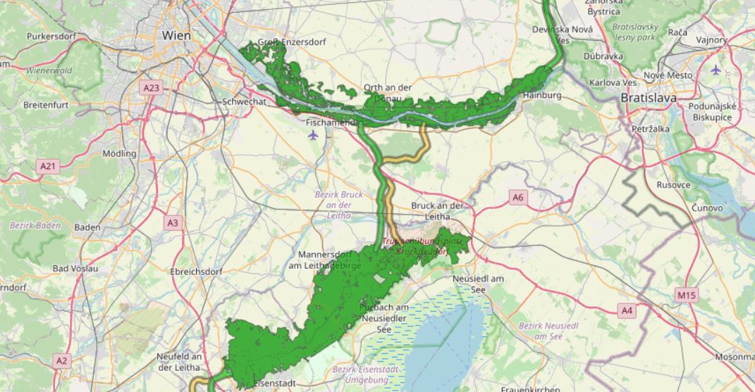
Alpine Carpathian Corridor (ACC Corridor)
Modeling the course of the Alpen Kaparten corridor. Consists of the four Bottlenecks and additional core zones of wildlife in-betweeen them.
Attributes:
-101 - primarily core zone, buffered from centerline 250m to each side
-102 - primarily border zone, buffered from core zone 150m
-201 - secondary core zone, buffered from centerline 250m to each side
-202 - secondary border zone, buffered from core zone 150m
-112 - primarily, core - and borderzone are together, buffered 400m from the centerline on each side
-0 - core zones of wildlife, big forested areas, only rough delineation
Simple
Information de l'identification
- Date (Création)
- 2018-01-01
- Edition
- Version 1
- But
- Modeling of the course of the Alpen Kaparten Corridor. For a detailed description of the designation methodology and further information and data sets on the Alpen Kaparten Corridor see: http://geo.ivfl.boku.ac.at/. The action plan developed within the project and further information on the project can be found at: http://www.alpenkarpatenkorridor.at/.
- Etat
- Accepté
A l’origine de
- Type de représentation spatiale
- Vecteur
Résolution spatiale
Echelle comparative
- Dénominateur
- 50000
- Catégorie ISO
-
- Biologie, faune et flore
Etendue
N
S
E
W
))
Etendue
Etendue temporelle
- Période
- 2018-01-01
- Fréquence de mise à jour
- Lorsque nécessaire
- Mots clés (Thème)
-
- Alpine Carpathian Corridor
- Mots clés
-
- World
Contraintes sur la ressource
- Contraintes d'accès
- Droit d’auteur / Droit moral (copyright)
- Contraintes d'utilisation
- Droit d’auteur / Droit moral (copyright)
- Langue
- English
- Encodage de caractères
- Utf8
- Informations supplémentaires
- Data set is not suitable for parcel delineation / analysis!
Informations sur la distribution
- Ressource en ligne
- Alpine Carpathian Corridor (ESRI Shapefile)
Généalogie des ressources
- Généralités sur la provenance
- For detailed information on the designation methodology and further details on data quality, see: http://geo.ivfl.boku.ac.at/
- Niveau
- Jeu de données
Information sur le système de référence
- Nom du système de référence
- EPSG: 32633
Métadonnées
- Identifiant de la fiche
- urn:uuid/a8add026-8ffe-4fc0-8d87-fb5866f20af4
- Langue
- English
- Encodage de caractères
- Utf8
- Langue
- Français
- Langue
- Deutsch
- Langue
- Chineseutres
- Langue
- Spanish; Castilian
- Langue
- Arabic
- Langue
- Russian
Point de contact
- Lien vers la métadonnée
- https://geonetwork.lebensraumvernetzung.at/geonetwork/srv/api/records/a8add026-8ffe-4fc0-8d87-fb5866f20af4
- Informations de date (Révision)
- 2022-08-23T19:00:39
- Informations de date (Création)
- 2009-07-02T14:46:24
Norme des métadonnées
- Titre
- ISO 19115-3
acc.JPG
Étendue spatiale
N
S
E
W

Ressources associées
Not available