 Lebensraumvernetzung Geodata
Ecological Corridors Upper Austria
Copy of template Modèle pour les données vecteur (multilingue) created at 2022-08-23T09:42:38Z
Wildtierkorridore Oberösterreich
Copy of template نموذج البيانات الموجهة (متعددة اللغات) created at 2022-08-23T09:42:38Z
Copy of template Шаблон для векторных данных (многоязычное) created at 2022-08-23T09:42:38Z
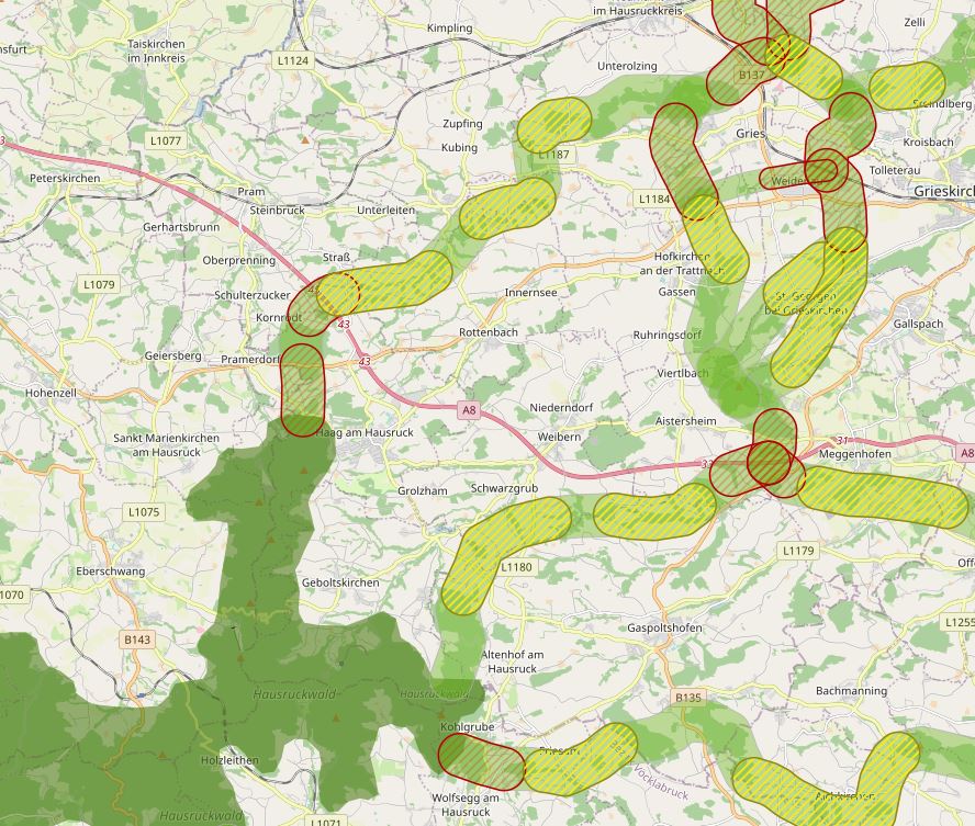
The specific designation of supra-regional migration corridors for larger, preferably forest-bound wildlife is intended to ensure, improve and, if necessary, restore the functionality of a statewide biotope and habitat network. For further information see: http://www.ooe-umweltanwaltschaft.at/xbcr/SID-B49D7CBE-852A8EF6/wildtierkorridore_ooe_2012.pdf
Mit der konkreten Ausweisung überregionaler Wanderkorridore für größere, bevorzugt waldgebundene Wildtiere soll die Funktionalität eines landesweit wirksamen Biotop- und Lebensraumverbunds sichergestellt, verbessert und gegebenenfalls wieder hergestellt werden. Weiterführende Informationen siehe: http://www.ooe-umweltanwaltschaft.at/xbcr/SID-B49D7CBE-852A8EF6/wildtierkorridore_ooe_2012.pdf
Simple
Information de l'identification
Identification info
Identification info
Identification info
Identification info
Identification info
Identification info
-
Date (Création)Date (Creation)Date (Creation)Date (Creation)Date (Creation)Date (Creation)Date (Creation)
- 2012-05-01
-
EditionEditionEditionEditionEditionEditionEdition
- Version 1
-
ButPurposePurposePurposePurposePurposePurpose
-
Visualization and safeguarding of habitat corridors in Upper AustriaErsichtlichmachung und Absicherung der Lebensraumkorridore in Oberösterreich
-
EtatStatusStatusStatusStatusStatusStatus
-
AcceptéAcceptedAcceptedAcceptedAcceptedAcceptedAccepted
A l’origine de
Originator
Originator
Originator
Originator
Originator
Originator
-
Type de représentation spatialeSpatial representation typeSpatial representation typeSpatial representation typeSpatial representation typeSpatial representation typeSpatial representation type
-
VecteurVectorVectorVectorVectorVectorVector
Résolution spatiale
Spatial resolution
Spatial resolution
Spatial resolution
Spatial resolution
Spatial resolution
Spatial resolution
Echelle comparative
Equivalent scale
Equivalent scale
Equivalent scale
Equivalent scale
Equivalent scale
Equivalent scale
-
DénominateurDenominatorDenominatorDenominatorDenominatorDenominatorDenominator
- 25000
-
Catégorie ISOTopic categoryTopic categoryTopic categoryTopic categoryTopic categoryTopic category
-
-
Biologie, faune et floreBiotaBiotaBiotaBiotaBiotaBiota
-
Etendue
Extent
Extent
Extent
Extent
Extent
Extent
))
Etendue
Extent
Extent
Extent
Extent
Extent
Extent
Etendue temporelle
Temporal extent
Temporal extent
Temporal extent
Temporal extent
Temporal extent
Temporal extent
-
PériodeTime periodTime periodTime periodTime periodTime periodTime period
- 2012-05-01
-
Fréquence de mise à jourMaintenance and update frequencyMaintenance and update frequencyMaintenance and update frequencyMaintenance and update frequencyMaintenance and update frequencyMaintenance and update frequency
-
IrrégulièreIrregularIrregularIrregularIrregularIrregularIrregular
- Keywords (ThèmeThemeThemeThemeThemeThemeTheme)
-
-
Upper AustriaOberösterreich
-
- Keywords (LocalisationPlacePlacePlacePlacePlacePlace)
-
-
World
-
Contraintes sur la ressource
Resource constraints
Resource constraints
Resource constraints
Resource constraints
Resource constraints
Resource constraints
-
Contraintes d'accèsAccess constraintsAccess constraintsAccess constraintsAccess constraintsAccess constraintsAccess constraints
-
Droit d’auteur / Droit moral (copyright)CopyrightCopyrightCopyrightCopyrightCopyrightCopyright
-
Contraintes d'utilisationUse constraintsUse constraintsUse constraintsUse constraintsUse constraintsUse constraints
-
Droit d’auteur / Droit moral (copyright)CopyrightCopyrightCopyrightCopyrightCopyrightCopyright
-
Autres contraintesOther constraintsOther constraintsOther constraintsOther constraintsOther constraintsOther constraints
-
Release cleared for any use. No parcel sharp demarcation. Intersections with the cadastre are prohibited.Freigabe für jegliche Nutzung freigegeben. Keine Parzellenscharfe Abgrenzung. Verschneidungen mit dem Kataster sind untersagt.
-
LangueLanguageLanguageLanguageLanguageLanguageLanguage
- English
-
Encodage de caractèresCharacter encodingCharacter encodingCharacter encodingCharacter encodingCharacter encodingCharacter encoding
-
Utf8UTF8UTF8UTF8UTF8UTF8UTF8
-
Informations supplémentairesSupplemental InformationSupplemental InformationSupplemental InformationSupplemental InformationSupplemental InformationSupplemental Information
-
No parcel sharp demarcation. Intersections with the cadastre are prohibited.Keine Parzellenscharfe Abgrenzung. Verschneidungen mit dem Kataster sind untersagt.
Informations sur la distribution
Distribution Information
Distribution Information
Distribution Information
Distribution Information
Distribution Information
Distribution Information
-
Ressource en ligneOnLine resourceOnLine resourceOnLine resourceOnLine resourceOnLine resourceOnLine resource
-
Data layers Ecological Corridors Upper Austria (ESRI-Shapefile)Lade von Webseite herunterAlle Datenschichten zur Lebensraumvernetzung in OÖ (ESRI-Shapefile)Lade von Webseite herunterLade von Webseite herunterLade von Webseite herunterLade von Webseite herunter
Alle Datenschichten zur Lebensraumvernetzung in OÖ (ESRI-Shapefile)
Généalogie des ressources
Resource lineage
Resource lineage
Resource lineage
Resource lineage
Resource lineage
Resource lineage
-
Généralités sur la provenanceStatementStatementStatementStatementStatementStatement
-
wtk-ooe_corridors. Polygons of all corridor sections in for habitat connectivity. Category A corridors (international) are 1000 m wide, Category B corridors (regional) are 500 m wide. The name of the corridors is found in the <name> field and is composed of that of a two-digit code and the category (e.g. GR_19A). wtk-ooe_yellowzones Polygons of all yellow zones (= corridor subsections with restricted functionality) in Upper Austria. The name of each yellow zone can be found in the <name> field, the assigned corridor section in the <corridor> field. At junctions of corridor sections, yellow zones can spatially overlap (with each other or also with red zones). wtk-ooe_redzones Polygons of all red zones (= corridor subsections with severely limited functionality) in Upper Austria. The name of each redzone is found in the <name> field, the assigned corridor section in the <corridor> field. At junctions of corridor sections, red zones can spatially overlap (among each other or also with yellow zones) wtk-ooe_habitats Polygons of current and potential habitat for forest-dwelling large mammals. Habitat quality is differentiated by zone. Transition zones (ÜZ in the <category> box) have medium habitat propensity, while core zones (KZ in the <category> box) have high habitat propensity. As so-called stepping stones (TS in the field <category>), the forests along the Danube were identified separately. In terms of habitat connectivity, these are equivalent to the core zones (or corridors) in terms of their importance. wtk-ooe_connection Line of the central corridor axis and its (partly hypothetical) course within the designated habitats to establish a nationwide closed habitat connectivity.wtk-ooe_korridore Polygone aller Korridorabschnitte in zur Lebensraumvernetzung. Kategorie-A-Korridore (international) sind 1000 m breit, Kategorie-B-Korridore (regional) 500 m. Die Bezeichnung der Korridore findet sich im Feld <Name> und setzt sich aus dem einer zweistelligen Kennzahl und der Kategorie zusammen (z.B. GR_19A). wtk-ooe_gelbzonen Polygone aller Gelbzonen (= Korridorteilabschnitte mit eingeschränkter Funktionalität) in Oberösterreich. Die Bezeichnung der einzelnen Gelbzonen findet sich im Feld <Name>, der zugeordnete Korridorabschnitt im Feld <Korridor>. An Verbindungsstellen von Korridorabschnitten können sich Gelbzonen (untereinander oder auch mit Rotzonen) räumlich überlagern. wtk-ooe_rotzonen Polygone aller Rotzonen (= Korridorteilabschnitte mit stark eingeschränkter Funktionalität) in Oberösterreich. Die Bezeichnung der einzelnen Rotzonen findet sich im Feld <Name>, der zugeordnete Korridorabschnitt im Feld <Korridor>. An Verbindungsstellen von Korridorabschnitten sich können sich Rotzonen (untereinander oder auch mit Gelbzonen) räumlich überlagern wtk-ooe_habitate Polygone aktueller und potentieller Lebensraum für waldgebundene Großsäuger. Die Habitat Qualität wird nach Zonen unterschieden. Übergangszonen (ÜZ im Feld <Kategorie>) weisen eine mittlere, Kernzonen (KZ im Feld <Kategorie>) eine hohe Habitateigung auf. Als sog. Trittsteine (TS im Feld <Kategorie>) wurden die Wälder entlang der Donau gesondert ausgewiesen. Diese sind in Bezug auf die Lebensraumvernetzung hinsichtlich ihrer Bedeutung mit den Kernzonen (bzw. den Korridoren) gleichzusetzen. wtk-ooe_verbund Linie der zentralen Korridorachse und ihres (teils hypothetischen) Verlaufs innerhalb der ausgewiesenen Habitate zur Herstellung eines landesweit geschlossenen Lebensraumverbunds.
-
NiveauHierarchy levelHierarchy levelHierarchy levelHierarchy levelHierarchy levelHierarchy level
-
Jeu de donnéesDatasetDatasetDatasetDatasetDatasetDataset
Information sur le système de référence
Reference System Information
Reference System Information
Reference System Information
Reference System Information
Reference System Information
Reference System Information
-
Nom du système de référenceReference system identifierReference system identifierReference system identifierReference system identifierReference system identifierReference system identifier
- EPSG:31255
Metadata
-
Identifiant de la ficheMetadata identifierMetadata identifierMetadata identifierMetadata identifierMetadata identifierMetadata identifier
- urn:uuid/cbdf846f-32e1-4a7d-a71f-3db6e4e3e0b6
-
LangueLanguageLanguageLanguageLanguageLanguageLanguage
- English
-
Encodage de caractèresCharacter encodingCharacter encodingCharacter encodingCharacter encodingCharacter encodingCharacter encoding
-
Utf8UTF8UTF8UTF8UTF8UTF8UTF8
-
LangueLanguageLanguageLanguageLanguageLanguageLanguage
- Français
-
LangueLanguageLanguageLanguageLanguageLanguageLanguage
- Deutsch
-
LangueLanguageLanguageLanguageLanguageLanguageLanguage
- Chineseutres
-
LangueLanguageLanguageLanguageLanguageLanguageLanguage
- Spanish; Castilian
-
LangueLanguageLanguageLanguageLanguageLanguageLanguage
- Arabic
-
LangueLanguageLanguageLanguageLanguageLanguageLanguage
- Russian
Point de contact
Point of contact
Point of contact
Point of contact
Point of contact
Point of contact
Point of contact
-
Lien vers la métadonnéeMetadata linkageMetadata linkageMetadata linkageMetadata linkageMetadata linkageMetadata linkage
- https://geonetwork.lebensraumvernetzung.at/geonetwork/srv/api/records/cbdf846f-32e1-4a7d-a71f-3db6e4e3e0b6
-
Informations de date (Création)Date info (Creation)Date info (Creation)Date info (Creation)Date info (Creation)Date info (Creation)Date info (Creation)
- 2022-08-23T10:00:03
-
Informations de date (Révision)Date info (Revision)Date info (Revision)Date info (Revision)Date info (Revision)Date info (Revision)Date info (Revision)
- 2022-08-23T10:16:50
Norme des métadonnées
Metadata standard
Metadata standard
Metadata standard
Metadata standard
Metadata standard
Metadata standard
-
TitreTitleTitleTitleTitleTitleTitle
-
ISO 19115-3ISO 19115-3
Overviews
Spatial extent
Provided by
