 Lebensraumvernetzung Geodata
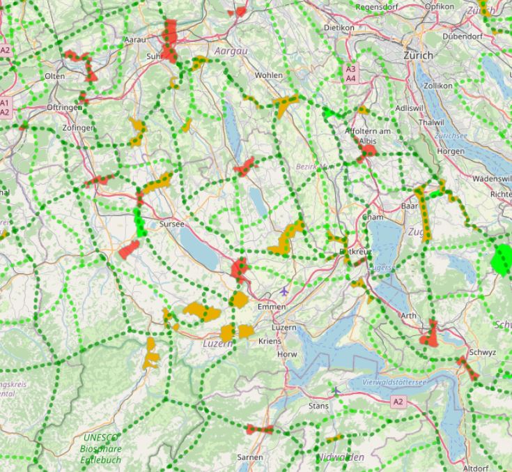
Wildtierkorridore von überregionaler Bedeutung in der Schweiz
In Switzerland, there are 304 wildlife corridors of supra-regional importance (as of 2020). They connect fragmented ecosystems or suitable habitats and are vital for wildlife. This is because roads and railways form insurmountable barriers for many wild animals.
Both large wild animals such as deer and stags, medium-sized ones such as foxes and hares, and small ones such as amphibians or bats need to be able to move for food and reproduction.
An assessment of wildlife corridors came to the following conclusion:
47 corridors (16%) are largely disrupted and can no longer be used by wildlife;
over half (171 corridors, 56%) are significantly to severely impaired;
less than a third (86 corridors, 28 %) can be classified as intact.
Geodata information:
In a first step, the known wildlife corridors were recorded canton by canton from existing data and potential corridors were identified using GIS and divided into wildlife corridors of supraregional, regional and local interest. Subsequently, the main features of the supraregional and regional network system were visualised for the whole of Switzerland. The corridors were then classified as wildlife corridors of supraregional or regional interest according to the importance of the axis on which they lie. The data for the connecting axes and wildlife corridors were recorded and processed in GIS by the Swiss Ornithological Institute Sempach. The supraregional corridors and the connecting axes were updated by the FOEN in 2012 on the basis of information provided by the cantonal hunting administrations.
Simple
Identification info
- Date (Creation)
- 2013-08
- Edition
- Version I
- Purpose
- Safeguarding wildlife corridors in Switzerland
- Status
- Accepted
- Spatial representation type
- Vector
Spatial resolution
Equivalent scale
- Denominator
- 50000
- Topic category
-
- Environment
- Biota
Extent
))
Extent
Temporal extent
- Time period
- 2013-08-10
- Maintenance and update frequency
- As needed
- Keywords (Place)
-
- Schweiz
- Schweiz
Resource constraints
- Access constraints
- Copyright
- Use constraints
- Language
- English
- Character encoding
- UTF8
- Supplemental Information
- Basis of survey: GIS data: Vector200, federal inventories, area statisticsData collection date: 1997 - 99, 2012, 2020, survey area: Switzerland (cantons)Data structure (geometry): Line datasets 1:200,000, Polygon datasets 1:200,000, 1:25,000.
Distribution Information
- OnLine resource
-
Wildlife corridors and connectivity system (ESRI shapefile)
Geodata: Connectivity axes and supraregional corridor sections in Switzerland. Source: https://www.bafu.admin.ch/bafu/de/home/themen/biodiversitaet/zustand/karten/geodaten.html
- OnLine resource
-
Web-Map-Application
Web map application on wildlife corridors and connectivity system in Switzerland
Resource lineage
- Statement
- In a first step, the known wildlife corridors were recorded canton by canton from existing data and potential corridors were identified using GIS and divided into wildlife corridors of supraregional, regional and local interest. Subsequently, the main features of the supraregional and regional network system were visualised for the whole of Switzerland. The corridors were then classified as wildlife corridors of supraregional or regional interest according to the importance of the axis on which they lie. The data for the connecting axes and wildlife corridors were recorded and processed in GIS by the Swiss Ornithological Institute Sempach. The supraregional corridors and the connecting axes were updated by the FOEN in 2012 on the basis of information provided by the cantonal hunting administrations.
- Hierarchy level
- Dataset
Reference System Information
- Reference system identifier
- EPSG 2056
Metadata
- Metadata identifier
- urn:uuid/f35faaac-b970-40a7-8896-a53376dee22f
- Language
- English
- Character encoding
- UTF8
- Language
- Français
- Language
- Deutsch
- Language
- Chineseutres
- Language
- Spanish; Castilian
- Language
- Arabic
- Language
- Russian
- Metadata linkage
- https://geonetwork.lebensraumvernetzung.at/geonetwork/srv/api/records/f35faaac-b970-40a7-8896-a53376dee22f
- Date info (Revision)
- 2022-08-25T12:25:01
- Date info (Creation)
- 2009-07-02T14:46:24
Metadata standard
- Title
- ISO 19115-3
Overviews
Spatial extent
Provided by
