 Lebensraumvernetzung Geodata
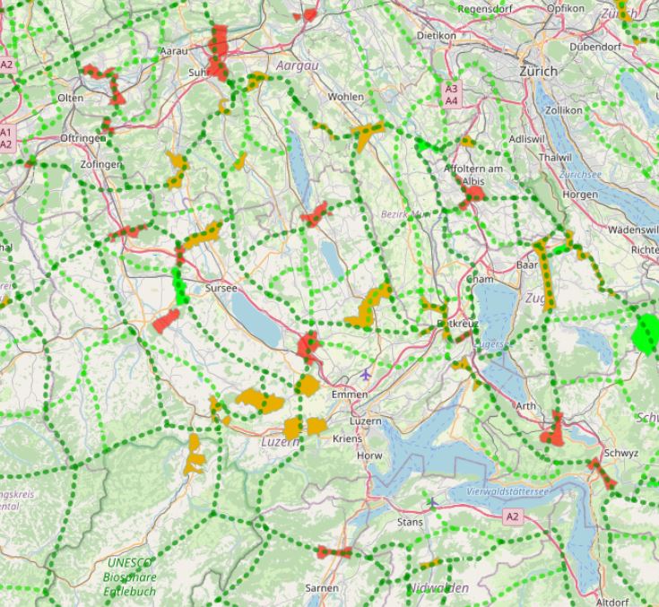
Wildtierkorridore von überregionaler Bedeutung in der Schweiz
Wildtierkorridore von überregionaler Bedeutung in der Schweiz
In Switzerland, there are 304 wildlife corridors of supra-regional importance (as of 2020). They connect fragmented ecosystems or suitable habitats and are vital for wildlife. This is because roads and railways form insurmountable barriers for many wild animals.
Both large wild animals such as deer and stags, medium-sized ones such as foxes and hares, and small ones such as amphibians or bats need to be able to move for food and reproduction.
An assessment of wildlife corridors came to the following conclusion:
47 corridors (16%) are largely disrupted and can no longer be used by wildlife;
over half (171 corridors, 56%) are significantly to severely impaired;
less than a third (86 corridors, 28 %) can be classified as intact.
Geodata information:
In a first step, the known wildlife corridors were recorded canton by canton from existing data and potential corridors were identified using GIS and divided into wildlife corridors of supraregional, regional and local interest. Subsequently, the main features of the supraregional and regional network system were visualised for the whole of Switzerland. The corridors were then classified as wildlife corridors of supraregional or regional interest according to the importance of the axis on which they lie. The data for the connecting axes and wildlife corridors were recorded and processed in GIS by the Swiss Ornithological Institute Sempach. The supraregional corridors and the connecting axes were updated by the FOEN in 2012 on the basis of information provided by the cantonal hunting administrations.
In der Schweiz existieren 304 Wildtierkorridore von überregionaler Bedeutung (Stand 2020). Sie verbinden fragmentierte Ökosysteme oder geeignete Lebensräume und sind für Wildtiere lebensnotwendig. Denn Strassen und Schienen bilden für viele wildlebende Tiere unüberwindbare Barrieren.
Sowohl grosse wildlebende Tiere wie Rehe und Hirsche, mittelgrosse wie Füchse und Hasen, aber auch kleine wie Amphibien oder Fledermäuse müssen sich für Nahrung und Fortpflanzung bewegen können.
Eine Beurteilung der Wildtierkorridore kam zu folgendem Schluss:
47 Korridore (16 %) sind weitgehend unterbrochen und können von Wildtieren nicht mehr benutzt werden;
über die Hälfte (171 Korridore, 56 %) sind nennenswert bis stark beeinträchtigt;
weniger als ein Drittel (86 Korridore, 28 %) kann als intakt eingestuft werden.
Information zu den Geodaten:
In einem ersten Schritt wurden aus bestehenden Daten die bekannten Wildtierkorridore kantonsweise erfasst sowie potentielle Korridore mittels GIS ermittelt und in Wildtierkorridore von überregionalem, regionalem und lokalen Interesse eingeteilt. Anschliessend wurde für die ganze Schweiz das überregionale und regionale Vernetzungssystem in den Grundzügen visualisiert. Die Korridore wurden dann entsprechend der Bedeutung der Achse, auf der sie liegen, als Wildtierkorridore von überregionalem resp. regionalem Interesse klassifiziert. Die Daten für die Verbindungsachsen und Wildtierkorridore wurden von der Schweizerischen Vogelwarte Sempach im GIS erfasst und bearbeitet. Die überregionalen Korridore und die Verbindungsachsen wurden aufgrund der Angaben der kantonalen Jagdverwaltungen 2012 durch das BAFU aktualisiert.
Simple
Information de l'identification
Identification info
Identification info
Identification info
Identification info
Identification info
Identification info
-
Date (Création)Date (Creation)Date (Creation)Date (Creation)Date (Creation)Date (Creation)Date (Creation)
- 2013-08
-
EditionEditionEditionEditionEditionEditionEdition
- Version I
-
ButPurposePurposePurposePurposePurposePurpose
-
Safeguarding wildlife corridors in SwitzerlandAbsicherung der Wildtierkorridore in der Schweiz
-
EtatStatusStatusStatusStatusStatusStatus
-
AcceptéAcceptedAcceptedAcceptedAcceptedAcceptedAccepted
A l’origine de
Originator
Originator
Originator
Originator
Originator
Originator
-
Type de représentation spatialeSpatial representation typeSpatial representation typeSpatial representation typeSpatial representation typeSpatial representation typeSpatial representation type
-
VecteurVectorVectorVectorVectorVectorVector
Résolution spatiale
Spatial resolution
Spatial resolution
Spatial resolution
Spatial resolution
Spatial resolution
Spatial resolution
Echelle comparative
Equivalent scale
Equivalent scale
Equivalent scale
Equivalent scale
Equivalent scale
Equivalent scale
-
DénominateurDenominatorDenominatorDenominatorDenominatorDenominatorDenominator
- 50000
-
Catégorie ISOTopic categoryTopic categoryTopic categoryTopic categoryTopic categoryTopic category
-
-
EnvironnementEnvironmentEnvironmentEnvironmentEnvironmentEnvironmentEnvironment
-
Biologie, faune et floreBiotaBiotaBiotaBiotaBiotaBiota
-
Etendue
Extent
Extent
Extent
Extent
Extent
Extent
))
Etendue
Extent
Extent
Extent
Extent
Extent
Extent
Etendue temporelle
Temporal extent
Temporal extent
Temporal extent
Temporal extent
Temporal extent
Temporal extent
-
PériodeTime periodTime periodTime periodTime periodTime periodTime period
- 2013-08-10
-
Fréquence de mise à jourMaintenance and update frequencyMaintenance and update frequencyMaintenance and update frequencyMaintenance and update frequencyMaintenance and update frequencyMaintenance and update frequency
-
Lorsque nécessaireAs neededAs neededAs neededAs neededAs neededAs needed
- Keywords (LocalisationPlacePlacePlacePlacePlacePlace)
-
-
Schweiz
-
SchweizSchweiz
-
Contraintes sur la ressource
Resource constraints
Resource constraints
Resource constraints
Resource constraints
Resource constraints
Resource constraints
-
Contraintes d'accèsAccess constraintsAccess constraintsAccess constraintsAccess constraintsAccess constraintsAccess constraints
-
Droit d’auteur / Droit moral (copyright)CopyrightCopyrightCopyrightCopyrightCopyrightCopyright
-
Contraintes d'utilisationUse constraintsUse constraintsUse constraintsUse constraintsUse constraintsUse constraints
-
LangueLanguageLanguageLanguageLanguageLanguageLanguage
- English
-
Encodage de caractèresCharacter encodingCharacter encodingCharacter encodingCharacter encodingCharacter encodingCharacter encoding
-
Utf8UTF8UTF8UTF8UTF8UTF8UTF8
-
Informations supplémentairesSupplemental InformationSupplemental InformationSupplemental InformationSupplemental InformationSupplemental InformationSupplemental Information
-
Basis of survey: GIS data: Vector200, federal inventories, area statisticsData collection date: 1997 - 99, 2012, 2020, survey area: Switzerland (cantons)Data structure (geometry): Line datasets 1:200,000, Polygon datasets 1:200,000, 1:25,000.Erhebungsgrundlagen: GIS-Daten: Vector200, Bundesinventare, ArealstatistikErhebungszeitpunkt der Grundlagendaten: 1997 - 99, 2012, 2020, Erhebungsgebiet: Schweiz (Kantone)Datenstruktur (Geometrie): Liniendatensätze 1:200'000, Polygondatensatze 1:200'000, 1:25'000
Informations sur la distribution
Distribution Information
Distribution Information
Distribution Information
Distribution Information
Distribution Information
Distribution Information
-
Ressource en ligneOnLine resourceOnLine resourceOnLine resourceOnLine resourceOnLine resourceOnLine resource
-
Wildlife corridors and connectivity system (ESRI shapefile)Lade eine Kopie herunterWildtierkorridore und Vernetzungssystem (ESRI-Shapefile)Lade eine Kopie herunterLade eine Kopie herunterLade eine Kopie herunterLade eine Kopie herunter
Geodata: Connectivity axes and supraregional corridor sections in Switzerland. Source: https://www.bafu.admin.ch/bafu/de/home/themen/biodiversitaet/zustand/karten/geodaten.htmlGeoddaten: Vernetzungsachsen und überregionale Korridorabschnitte in der Schweiz. Quelle: https://www.bafu.admin.ch/bafu/de/home/themen/biodiversitaet/zustand/karten/geodaten.html
-
Ressource en ligneOnLine resourceOnLine resourceOnLine resourceOnLine resourceOnLine resourceOnLine resource
-
Web-Map-Application
Web map application on wildlife corridors and connectivity system in SwitzerlandWebkartenapplikation zum Thema Wildtierkorridore und Vernetzungssystem in der Schweiz
Généalogie des ressources
Resource lineage
Resource lineage
Resource lineage
Resource lineage
Resource lineage
Resource lineage
-
Généralités sur la provenanceStatementStatementStatementStatementStatementStatement
-
In a first step, the known wildlife corridors were recorded canton by canton from existing data and potential corridors were identified using GIS and divided into wildlife corridors of supraregional, regional and local interest. Subsequently, the main features of the supraregional and regional network system were visualised for the whole of Switzerland. The corridors were then classified as wildlife corridors of supraregional or regional interest according to the importance of the axis on which they lie. The data for the connecting axes and wildlife corridors were recorded and processed in GIS by the Swiss Ornithological Institute Sempach. The supraregional corridors and the connecting axes were updated by the FOEN in 2012 on the basis of information provided by the cantonal hunting administrations.In einem ersten Schritt wurden aus bestehenden Daten die bekannten Wildtierkorridore kantonsweise erfasst sowie potentielle Korridore mittels GIS ermittelt und in Wildtierkorridore von überregionalem, regionalem und lokalen Interesse eingeteilt. Anschliessend wurde für die ganze Schweiz das überregionale und regionale Vernetzungssystem in den Grundzügen visualisiert. Die Korridore wurden dann entsprechend der Bedeutung der Achse, auf der sie liegen, als Wildtierkorridore von überregionalem resp. regionalem Interesse klassifiziert. Die Daten für die Verbindungsachsen und Wildtierkorridore wurden von der Schweizerischen Vogelwarte Sempach im GIS erfasst und bearbeitet. Die überregionalen Korridore und die Verbindungsachsen wurden aufgrund der Angaben der kantonalen Jagdverwaltungen 2012 durch das BAFU aktualisiert.
-
NiveauHierarchy levelHierarchy levelHierarchy levelHierarchy levelHierarchy levelHierarchy level
-
Jeu de donnéesDatasetDatasetDatasetDatasetDatasetDataset
Information sur le système de référence
Reference System Information
Reference System Information
Reference System Information
Reference System Information
Reference System Information
Reference System Information
-
Nom du système de référenceReference system identifierReference system identifierReference system identifierReference system identifierReference system identifierReference system identifier
- EPSG 2056
Metadata
-
Identifiant de la ficheMetadata identifierMetadata identifierMetadata identifierMetadata identifierMetadata identifierMetadata identifier
- urn:uuid/f35faaac-b970-40a7-8896-a53376dee22f
-
LangueLanguageLanguageLanguageLanguageLanguageLanguage
- English
-
Encodage de caractèresCharacter encodingCharacter encodingCharacter encodingCharacter encodingCharacter encodingCharacter encoding
-
Utf8UTF8UTF8UTF8UTF8UTF8UTF8
-
LangueLanguageLanguageLanguageLanguageLanguageLanguage
- Français
-
LangueLanguageLanguageLanguageLanguageLanguageLanguage
- Deutsch
-
LangueLanguageLanguageLanguageLanguageLanguageLanguage
- Chineseutres
-
LangueLanguageLanguageLanguageLanguageLanguageLanguage
- Spanish; Castilian
-
LangueLanguageLanguageLanguageLanguageLanguageLanguage
- Arabic
-
LangueLanguageLanguageLanguageLanguageLanguageLanguage
- Russian
Point de contact
Point of contact
Point of contact
Point of contact
Point of contact
Point of contact
Point of contact
-
Lien vers la métadonnéeMetadata linkageMetadata linkageMetadata linkageMetadata linkageMetadata linkageMetadata linkage
- https://geonetwork.lebensraumvernetzung.at/geonetwork/srv/api/records/f35faaac-b970-40a7-8896-a53376dee22f
-
Informations de date (Révision)Date info (Revision)Date info (Revision)Date info (Revision)Date info (Revision)Date info (Revision)Date info (Revision)
- 2022-08-25T12:25:01
-
Informations de date (Création)Date info (Creation)Date info (Creation)Date info (Creation)Date info (Creation)Date info (Creation)Date info (Creation)
- 2009-07-02T14:46:24
Norme des métadonnées
Metadata standard
Metadata standard
Metadata standard
Metadata standard
Metadata standard
Metadata standard
-
TitreTitleTitleTitleTitleTitleTitle
-
ISO 19115-3
Overviews
Spatial extent
Provided by
