 Lebensraumvernetzung Geodata
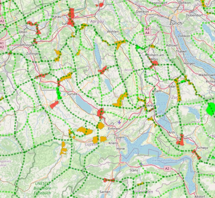
Wildtierkorridore von überregionaler Bedeutung in der Schweiz
In Switzerland, there are 304 wildlife corridors of supra-regional importance (as of 2020). They connect fragmented ecosystems or suitable habitats and are vital for wildlife. This is because roads and railways form insurmountable barriers for many wild animals.
Both large wild animals such as deer and stags, medium-sized ones such as foxes and hares, and small ones such as amphibians or bats need to be able to move for food and reproduction.
An assessment of wildlife corridors came to the following conclusion:
47 corridors (16%) are largely disrupted and can no longer be used by wildlife;
over half (171 corridors, 56%) are significantly to severely impaired;
less than a third (86 corridors, 28 %) can be classified as intact.
Geodata information:
In a first step, the known wildlife corridors were recorded canton by canton from existing data and potential corridors were identified using GIS and divided into wildlife corridors of supraregional, regional and local interest. Subsequently, the main features of the supraregional and regional network system were visualised for the whole of Switzerland. The corridors were then classified as wildlife corridors of supraregional or regional interest according to the importance of the axis on which they lie. The data for the connecting axes and wildlife corridors were recorded and processed in GIS by the Swiss Ornithological Institute Sempach. The supraregional corridors and the connecting axes were updated by the FOEN in 2012 on the basis of information provided by the cantonal hunting administrations.
Simple
Information de l'identification
- Date (Création)
- 2013-08
- Edition
- Version I
- But
- Safeguarding wildlife corridors in Switzerland
- Etat
- Accepté
- Type de représentation spatiale
- Vecteur
Résolution spatiale
Echelle comparative
- Dénominateur
- 50000
- Catégorie ISO
-
- Environnement
- Biologie, faune et flore
Etendue
))
Etendue
Etendue temporelle
- Période
- 2013-08-10
- Fréquence de mise à jour
- Lorsque nécessaire
- Mots clés (Localisation)
-
- Schweiz
- Schweiz
Contraintes sur la ressource
- Contraintes d'accès
- Droit d’auteur / Droit moral (copyright)
- Contraintes d'utilisation
- Langue
- English
- Encodage de caractères
- Utf8
- Informations supplémentaires
- Basis of survey: GIS data: Vector200, federal inventories, area statisticsData collection date: 1997 - 99, 2012, 2020, survey area: Switzerland (cantons)Data structure (geometry): Line datasets 1:200,000, Polygon datasets 1:200,000, 1:25,000.
Informations sur la distribution
- Ressource en ligne
-
Wildlife corridors and connectivity system (ESRI shapefile)
Geodata: Connectivity axes and supraregional corridor sections in Switzerland. Source: https://www.bafu.admin.ch/bafu/de/home/themen/biodiversitaet/zustand/karten/geodaten.html
- Ressource en ligne
-
Web-Map-Application
Web map application on wildlife corridors and connectivity system in Switzerland
Généalogie des ressources
- Généralités sur la provenance
- In a first step, the known wildlife corridors were recorded canton by canton from existing data and potential corridors were identified using GIS and divided into wildlife corridors of supraregional, regional and local interest. Subsequently, the main features of the supraregional and regional network system were visualised for the whole of Switzerland. The corridors were then classified as wildlife corridors of supraregional or regional interest according to the importance of the axis on which they lie. The data for the connecting axes and wildlife corridors were recorded and processed in GIS by the Swiss Ornithological Institute Sempach. The supraregional corridors and the connecting axes were updated by the FOEN in 2012 on the basis of information provided by the cantonal hunting administrations.
- Niveau
- Jeu de données
Information sur le système de référence
- Nom du système de référence
- EPSG 2056
Métadonnées
- Identifiant de la fiche
- urn:uuid/f35faaac-b970-40a7-8896-a53376dee22f
- Langue
- English
- Encodage de caractères
- Utf8
- Langue
- Français
- Langue
- Deutsch
- Langue
- Chineseutres
- Langue
- Spanish; Castilian
- Langue
- Arabic
- Langue
- Russian
- Lien vers la métadonnée
- https://geonetwork.lebensraumvernetzung.at/geonetwork/srv/api/records/f35faaac-b970-40a7-8896-a53376dee22f
- Informations de date (Révision)
- 2022-08-25T12:25:01
- Informations de date (Création)
- 2009-07-02T14:46:24
Norme des métadonnées
- Titre
- ISO 19115-3
Étendue spatiale
