 Lebensraumvernetzung Geodata
Aktuelle Version Lebensraumkorridore Österreich (Version 2025-09-15)
LRVA-2025: Current version of the integral dataset on habitat connectivity in Austria. This dataset takes into account all datasets and designations of habitat corridors from scientific projects and public sector projects (federal provinces). The dataset has been evaluated by the experts of the Cooridnation Platform "Habitat Connectivity Austria" and is updated as soon as new information and designations from projects are available. Further details are available in the endreport: https://docs.umweltbundesamt.at/s/AzZrHid6q9wkDDM
As part of the update, the underlying data model was adapted. It is now possible to track all changes made during the update. All updated and valid habitat corridors can be obtained by selecting all edges that have the value “true” in the “valid” data set property. All edges with the value “false” are no longer valid. The reasons for the changes are noted in the ‘comment’ data record property. Most of the changes are so-called “technical changes.” As part of these changes, corridors have been adapted accordingly due to errors in the spatial location of existing crossing structures. The reclassification of corridors is due to new planned or adapted locations of wildlife crossing aids along the existing route.
Description of the feature properties see feature catalog:
Data set download at: https://docs.umweltbundesamt.at/s/ep9JF44TjYxDY54,
also includes QGIS project for direct use of the GPKG file. Two visualizations available.
- Corridors classified by corridor category (supra-regional | regional | local) (see Quicklook)
- Change layer: Current corridors and all outdated/revised corridor sections
Simple
Identification info
- Date (Last Update)
- 2025-09-15
- Edition
- Version 2025-09-15
- Purpose
- Basis for protecting ecological corridors in spatial planning and by nature conservation. Basis for the consideration of ecological corridors in nature conservation planning.
- Status
- Valid
Point of contact
- Spatial representation type
- Vector
Spatial resolution
Equivalent scale
- Denominator
- 25000
- Topic category
-
- Environment
Extent
))
Extent
Temporal extent
- Time period
- 2022-07-01
- Maintenance and update frequency
- Continual
- Keywords
-
- Austria2025
- LRVA-2025
- Keywords
-
- Austria
Resource constraints
- Access constraints
- Other restrictions
- Use constraints
- Other restrictions
- Other constraints
- Creative Commons Lizenz CC-BY-AT 4.0
- Language
- Deutsch
- Character encoding
- UTF8
- Supplemental Information
- See Report: https://geonode.lebensraumvernetzung.at/documents/107/download
Content Information
- Feature catalogue citation
Distribution Information
- OnLine resource
-
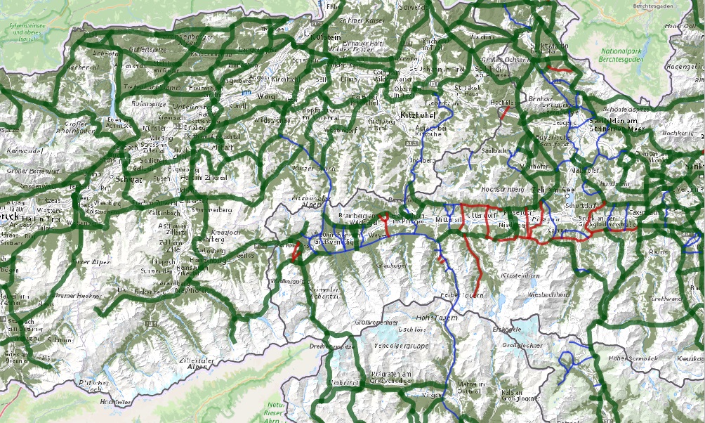
Map of the resource
Map ecological corridors Austria
- OnLine resource
-
Download dataset (Geopackage-format - 50 MB)
Includes QGIS project for direct use of the GPKG file. Two visualizations available. - Corridors classified by corridor category (supra-regional
- OnLine resource
-
lrv:Lebensraumkorridore_Version_2025
Lebensraumkorridore Version 2025
- OnLine resource
-
lrv:Lebensraumkorridore_Version_2025
Lebensraumkorridore Version 2025
Resource lineage
- Statement
- Data set takes into account all existing data sets from scientific projects and projects of the public sector (federal states). All datasets considered are referenced in the linked resources and are also available in this portal.
- Hierarchy level
- Dataset
- Source
-
- Alpen Karpaten Korridor (ACC-Korridor)
- Lebensraumkorridore Salzburg
- Wildökologische Korridore Steiermark (NATREG_Wildkorridore)
- Wildtierkorridore Oberösterreich
- Veraltet: Lebensraumkorridore Österreich - Version 2018
- ConNat . Connecting Nature
- Wildkatzenkorridor Niederösterreich
- Deprecated: LRVA-2022: Lebensraumkorridore Österreich (Version 2022-10-16)
Reference System Information
- Reference system identifier
- EPSG: 31287
Metadata
- Metadata identifier
- urn:uuid/90e852dc-8cb5-4f8d-a571-daa333d3ef64
- Language
- English
- Character encoding
- UTF8
- Language
- Français
- Language
- Deutsch
- Language
- Chineseutres
- Language
- Spanish; Castilian
- Language
- Arabic
- Language
- Russian
Point of contact
- Metadata linkage
- https://geonetwork.lebensraumvernetzung.at/geonetwork/srv/api/records/90e852dc-8cb5-4f8d-a571-daa333d3ef64
- Date info (Revision)
- 2025-10-23T11:15:19
- Date info (Creation)
- 2022-07-01T14:46:24
Metadata standard
- Title
- ISO 19115-3
Overviews
Spatial extent
Provided by
