 Lebensraumvernetzung Geodata
Deprecated: LRVA-2022: Lebensraumkorridore Österreich (Version 2022-10-16)
LRVA-2022: Current version of the integral dataset on habitat connectivity in Austria. This dataset takes into account all datasets and designations of habitat corridors from scientific projects and public sector projects (federal provinces). The dataset has been evaluated by the experts of the Cooridnation Platform "Habitat Connectivity Austria" and is updated as soon as new information and designations from projects are available. Further details are available in the endreport: https://docs.umweltbundesamt.at/s/AzZrHid6q9wkDDM
Simple
Identification info
- Date (Last Update)
- 2022-07-01
- Edition
- Version 2022-10-16
- Purpose
- Basis for protecting ecological corridors in spatial planning and by nature conservation. Basis for the consideration of ecological corridors in nature conservation planning.
- Status
- Deprecated
Point of contact
- Spatial representation type
- Vector
Spatial resolution
Equivalent scale
- Denominator
- 25000
- Topic category
-
- Environment
Extent
))
Extent
Temporal extent
- Time period
- 2022-07-01
- Maintenance and update frequency
- Continual
- Keywords (Place)
-
- Austria2022
- LRVA-2022
- Keywords
-
- Austria
Resource constraints
- Access constraints
- Other restrictions
- Use constraints
- Other restrictions
- Other constraints
- Creative Commons Lizenz CC-BY-AT 4.0
- Language
- Deutsch
- Character encoding
- UTF8
- Supplemental Information
- See Report: https://geonode.lebensraumvernetzung.at/documents/107/download
Distribution Information
- OnLine resource
-
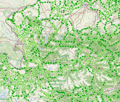
Map of the resource
Map ecological corridors Austria
- OnLine resource
-
Download dataset (Geopackage-format)
Includes all layer files (nodes, edges, ninimum areas) of the ecological network Austria. A QGIS-project file is also provides. Styles for the layers are directly stored in the geopackage
- OnLine resource
-
geonode:LRVA_Linestring_Version_2022_10_16
LRVA_Linestring_Version_2022_10_16
- OnLine resource
-
geonode:LRVA_Nodes_Version_2022_10_16
Download WFS: Nodes of the ecological network graph
- OnLine resource
-
geonode:LRVA_Polygon_Version_2022_10_16
LRVA_Polygon_Version_2022_10_16
- OnLine resource
-
geonode:LRVA_Linestring_Version_2022_10_16
WMS: Egdes of ecological network graph
- OnLine resource
-
geonode:LRVA_Nodes_Version_2022_10_16
LRVA_Nodes_Version_2022_10_16
- OnLine resource
-
geonode:LRVA_Polygon_Version_2022_10_16
WMS: Minimum area of ecological corridors
Resource lineage
- Statement
- Data set takes into account all existing data sets from scientific projects and projects of the public sector (federal states). All datasets considered are referenced in the linked resources and are also available in this portal.
- Hierarchy level
- Dataset
Reference System Information
- Reference system identifier
- EPSG: 31287
Metadata
- Metadata identifier
- urn:uuid/a3a34de2-7431-4344-ad0a-b38b8b0bc663
- Language
- English
- Character encoding
- UTF8
- Language
- Français
- Language
- Deutsch
- Language
- Chineseutres
- Language
- Spanish; Castilian
- Language
- Arabic
- Language
- Russian
Point of contact
- Metadata linkage
- https://geonetwork.lebensraumvernetzung.at/geonetwork/srv/api/records/a3a34de2-7431-4344-ad0a-b38b8b0bc663
- Date info (Revision)
- 2025-10-23T11:15:56
- Date info (Creation)
- 2022-07-01T14:46:24
Metadata standard
- Title
- ISO 19115-3
Overviews
Spatial extent
Provided by
