 Lebensraumvernetzung Geodata
Deprecated: LRVA-2022: Lebensraumkorridore Österreich (Version 2022-10-16)
LRVA-2022: Current version of the integral dataset on habitat connectivity in Austria. This dataset takes into account all datasets and designations of habitat corridors from scientific projects and public sector projects (federal provinces). The dataset has been evaluated by the experts of the Cooridnation Platform "Habitat Connectivity Austria" and is updated as soon as new information and designations from projects are available. Further details are available in the endreport: https://docs.umweltbundesamt.at/s/AzZrHid6q9wkDDM
Simple
Information de l'identification
- Date (Dernière mise à jour)
- 2022-07-01
- Edition
- Version 2022-10-16
- But
- Basis for protecting ecological corridors in spatial planning and by nature conservation. Basis for the consideration of ecological corridors in nature conservation planning.
- Etat
- Déprecié
Point de contact
- Type de représentation spatiale
- Vecteur
Résolution spatiale
Echelle comparative
- Dénominateur
- 25000
- Catégorie ISO
-
- Environnement
Etendue
))
Etendue
Etendue temporelle
- Période
- 2022-07-01
- Fréquence de mise à jour
- Continue
- Mots clés (Localisation)
-
- Austria2022
- LRVA-2022
- Mots clés
-
- Austria
Contraintes sur la ressource
- Contraintes d'accès
- Autres restrictions
- Contraintes d'utilisation
- Autres restrictions
- Autres contraintes
- Creative Commons Lizenz CC-BY-AT 4.0
- Langue
- Deutsch
- Encodage de caractères
- Utf8
- Informations supplémentaires
- See Report: https://geonode.lebensraumvernetzung.at/documents/107/download
Informations sur la distribution
- Ressource en ligne
-
Map of the resource
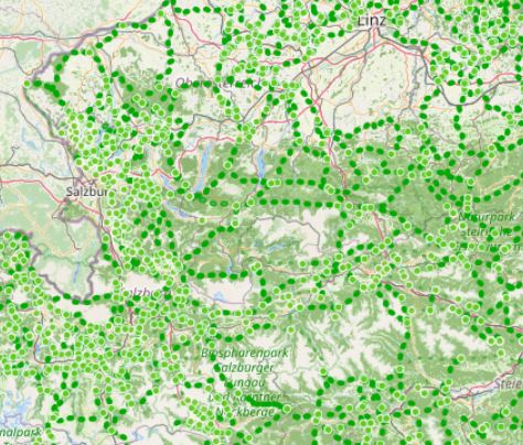
Map ecological corridors Austria
- Ressource en ligne
-
Download dataset (Geopackage-format)
Includes all layer files (nodes, edges, ninimum areas) of the ecological network Austria. A QGIS-project file is also provides. Styles for the layers are directly stored in the geopackage
- Ressource en ligne
-
geonode:LRVA_Linestring_Version_2022_10_16
LRVA_Linestring_Version_2022_10_16
- Ressource en ligne
-
geonode:LRVA_Nodes_Version_2022_10_16
Download WFS: Nodes of the ecological network graph
- Ressource en ligne
-
geonode:LRVA_Polygon_Version_2022_10_16
LRVA_Polygon_Version_2022_10_16
- Ressource en ligne
-
geonode:LRVA_Linestring_Version_2022_10_16
WMS: Egdes of ecological network graph
- Ressource en ligne
-
geonode:LRVA_Nodes_Version_2022_10_16
LRVA_Nodes_Version_2022_10_16
- Ressource en ligne
-
geonode:LRVA_Polygon_Version_2022_10_16
WMS: Minimum area of ecological corridors
Généalogie des ressources
- Généralités sur la provenance
- Data set takes into account all existing data sets from scientific projects and projects of the public sector (federal states). All datasets considered are referenced in the linked resources and are also available in this portal.
- Niveau
- Jeu de données
- Source
-
- Alpine Carpathian Corridor (ACC Corridor)
- Ecological Corridors Salzburg
- Ecological Corridors Stryria
- Copy of template Modèle pour les données vecteur (multilingue) created at 2022-08-23T09:42:38Z
- Deprecated: Austrian Ecological Corridors - Version 2018
- ConNat . Connecting Nature
- Wildcat Corridors Lower Austria
Information sur le système de référence
- Nom du système de référence
- EPSG: 31287
Métadonnées
- Identifiant de la fiche
- urn:uuid/a3a34de2-7431-4344-ad0a-b38b8b0bc663
- Langue
- English
- Encodage de caractères
- Utf8
- Langue
- Français
- Langue
- Deutsch
- Langue
- Chineseutres
- Langue
- Spanish; Castilian
- Langue
- Arabic
- Langue
- Russian
Point de contact
- Lien vers la métadonnée
- https://geonetwork.lebensraumvernetzung.at/geonetwork/srv/api/records/a3a34de2-7431-4344-ad0a-b38b8b0bc663
- Informations de date (Révision)
- 2025-10-23T11:15:56
- Informations de date (Création)
- 2022-07-01T14:46:24
Norme des métadonnées
- Titre
- ISO 19115-3
Étendue spatiale
